Zion
A river you could wade cut this whole canyon, one grain of sand at a time.
Also seen through Desert & Deep Time · all at Zion Canyon →.
Why here
Stand on the canyon floor and the river barely reaches your knees. The North Fork of the Virgin River is a modest stream, clear or muddy by the day, easy to wade across — and it has cut a gorge nearly half a mile deep through solid stone. That is the whole argument of this place: not force, but patience. The rock it cuts was once a country of desert dunes, wind-piled sand later pressed into tan and reddish sandstone long before the river ever arrived. Water works this canyon in two ways. The river cuts down, hauling sand toward the sea a little more each spring. And rain that soaks into the porous rock travels slowly downward, then leaks out along the cliffs to feed green gardens on bare desert stone. Everywhere you look here, water is winning a long, quiet argument with the desert — and the desert is still there to see, frozen in every wall. Follow the water, and the canyon stops being scenery and starts reading like a story.
The story
Begin with sand. Long before the river, this corner of the plateau was a desert of great dunes — wind-piled sand that hardened, over ages, into the tan and reddish stone that now stands in cliffs. It is only one chapter in a taller stack: the rock exposed around Zion records something like 150 million years of shallow seas, streams, and deserts, a stair-step of layers geologists trace across the whole region.
Then the river went to work. The North Fork of the Virgin River found this soft sandstone and cut down into it, carving a gorge deep and narrow, its walls rising nearly half a mile above the water. Where the road runs the canyon holds four different worlds at once — dry desert, the green ribbon of the riverbank, oak woodland, and cool forest above — so that a mule deer browsing at the meadow edge and a lizard on hot rock can share the same afternoon.
People come late to the record we can read here. In the 1920s a rail company built the canyon’s lodge, a modest cluster of cabins meant to draw travelers off the train and into the gorge; the canyon has pulled visitors for a long time. The older human story — who lived and walked here first — the payload keeps mostly quiet, so this note does too, and lets the rock and the river carry the telling.
The sites
The river's long argument
Big Bend Viewpoint
37.2726, −112.9466
Big Bend is where the canyon shows its hand. The river swings in a wide curve below the road, and from the viewpoint you can see both the water at the bottom and the towering walls it has cut — nearly half a mile of stone above a stream you could wade across. That contrast between the great height of the cliffs and the smallness of the river is the whole lesson of Zion in a single glance. This canyon was not blasted open; it was worn down, slowly, by moving water carrying sand. Spring runoff runs high and brown with the load it hauls; late summer often shrinks it to a clear trickle over gravel. Above the walls, keep an eye on the sky. Very large dark birds ride the updrafts here — California condors have been seen soaring these cliffs, and their wingspan makes even a distant bird look wrong-sized against the rock.
From the viewpoint, follow the river’s bend with your eye, then look straight up the wall above it. The stream is the tool and the whole cliff is what it has removed — the muddier the water runs, the more sand it is carrying out of the canyon that very day.
- AccessDrive-up
- ExertionEasy
- TimeAn hour
Grotto Trailhead
37.2520, −112.9560
The Grotto puts you right at the water. A short walk from the road brings you to the riverbank under big box elders, where the river runs close enough to touch and the canyon walls lean in overhead. This is the best place to watch the river actually doing its work — running clear over gravel bars, undercutting the bank on the outside of each bend, dropping sand on the inside. Sit a while by the current. In the fast water, look for a small slate-gray bird that bobs on the rocks and then walks straight into the rushing stream to feed along the bottom. That is the American dipper, one of the few songbirds that hunts underwater, and a good sign of a clean, lively river. The streamside trees give shade and birdsong in spring, and a run of gold in fall.
Stand at the river’s edge and pick a spot where the current runs fast over stones. Watch for the American dipper — a plump gray bird that dips at the knees, then disappears underwater and walks the streambed for insects, surfacing downstream as if nothing had happened.
- AccessShort walk
- ExertionEasy
- TimeAn hour
Zion Lodge
37.2525, −112.9568
The lodge sits on a broad green bench on the canyon floor, a good place to stop and read the whole canyon at once. A rail company built this cluster of cabins in the 1920s, meant to draw travelers off the train and into the gorge — the canyon has been a destination for a long time, and the lodge is where that human story is easiest to see. The open lawn and woodland around it are also where the canyon’s larger animals come to browse. Mule deer step out at the meadow edges, wild turkeys work the grass in loose flocks, and rock squirrels are common enough to spot darting between the benches. Stand on the lawn and turn a slow circle. The walls rise on every side, each a different face of the same tan-and-red sandstone, and the river runs quietly just beyond the trees — rock and water framing the one flat spot where people chose to stay.
From the lodge lawn at dawn or dusk, scan the grassy edges where the meadow meets the trees. Mule deer feed here in the cool hours — look for the oversized ears they are named for, swiveling to catch sound while they graze.
- AccessDrive-up
- ExertionEasy
- TimeAn hour
Water inside the stone
Emerald Pools Trailhead
37.2510, −112.9584
This is where you meet the canyon’s other kind of water — not the river cutting down, but rain moving slowly through the rock itself. The sandstone is porous, so rain and snowmelt soak in at the top of the cliffs and travel down through the stone for years, until they reach a tighter layer they cannot cross. There the water turns sideways and leaks out along the cliff face as a line of seeps. The trail leads to alcoves where this seeping water drips steadily off the rock and feeds hanging gardens — bright cushions of moss and fern clinging to bare stone in the middle of the desert. Look for black maidenhair fern, its delicate fan-shaped leaflets on thin dark stems, growing only where the wall stays wet. The lower pool is an easy walk; the upper pools climb steeper and can be slick where the water crosses the path.
At a dripping alcove, hold your hand under the seep line where water beads off the rock, then look at what grows only there. The maidenhair fern lives on this slow leak alone — a green garden fed by rain that fell on the clifftop years before it reached this wall.
- AccessShort walk
- ExertionModerate
- TimeHalf a day
Court of the Patriarchs
37.2371, −112.9605
A short climb from the road reaches a viewpoint facing three great sandstone peaks standing shoulder to shoulder across the canyon. They are worth a long look not only for their size but for what is painted down their faces — long vertical streaks of black and rust running from the clifftops toward the base. Those stains are the slow signature of water too. When rain runs down the bare rock, it carries dissolved minerals and, over centuries, leaves them behind as dark varnish along the paths it takes again and again, so the streaks map where water reliably flows down the wall. The rock itself is the old dune sandstone that makes all of Zion, tan where it is fresh and reddened where iron has rusted at the surface. Morning light throws the whole court into relief; midday flattens it.
From the viewpoint, look at the tall cliff faces across the canyon and trace the dark vertical streaks from top to bottom. Each stripe marks a route rainwater takes down the bare stone over and over, leaving a stain of minerals behind — the wall keeping a record of where the water runs.
- AccessShort walk
- ExertionEasy
- TimeAn hour
The frozen dunes overhead
Canyon Overlook
37.2133, −112.9460
This short trail on the canyon’s east side ends at a railed lookout with a long view down into the main gorge — a different vantage from the canyon floor, looking down the length of the cut rather than up the walls. It is also one of the best places to read the frozen desert in the rock. Along the trail, look closely at the sandstone underfoot and in the low walls beside you. It is not plain stone but ruled through with long sweeping lines that curve and cross each other at angles. Those are the preserved faces of ancient sand dunes. Each set of lines is the slope of a dune the wind built and then buried, over and over, before the whole desert hardened into rock. On the dry ledges here, watch for pricklypear cactus and stiff little scrub oak — desert plants holding the sunny rock above the shaded river world below.
Kneel by the sandstone along the trail and find the long, curved lines running through it at a slant. Each is the buried face of a sand dune — trace how one set of lines is cut off sharply by the next, the record of wind piling and reworking this desert grain by grain.
- AccessShort walk
- ExertionModerate
- TimeAn hour
The Great White Throne
37.2611, −112.9411
Seen from the canyon floor near Big Bend, the Great White Throne rises as a single massive block of sandstone lifting in a sheer face from the riverside forest. It shows plainly how much rock the river has removed: the throne was not built up, it is what stood when the water cut everything around it away. The pale upper rock is the same sandstone that runs red lower in the canyon. Near the surface, iron in the stone has rusted and stained the lower walls, while the higher rock stays close to its original bleached color, so a single cliff can shade from red at its foot to near-white at its crown. In late afternoon a low sun sets the whole face glowing. This is a monolith to watch, not to climb.
From the canyon floor, look at the Great White Throne and follow its color from bottom to top. The red foot and the pale crown are the same rock — the lower stone stained by rusted iron near the surface, the upper stone still close to the bleached color of the ancient dune sand it was made from.
- AccessDrive-up
- ExertionEasy
- TimeAn hour
Angels Landing
37.2693, −112.9480
Angels Landing is a narrow fin of sandstone standing out into the middle of the canyon, and its shape is a lesson in how the river works. Swinging through its bends, the Virgin River cut down on both sides of this spur of rock and left it isolated — a thin blade with the canyon dropping away steeply on either hand. The trail to its top is a serious climb along an exposed ridge; the final stretch is narrow, high, and not for anyone uneasy with heights or caught in hard weather. Those who go up trade the effort for a view straight down the canyon and its river. Overhead on the thermals, watch for very large soaring birds — California condors range these cliffs, drawn to the height and the updrafts the rock provides.
From the spine of the ridge, or looking up at it from the canyon floor, notice how the fin stands alone with the canyon falling away on both sides. The river cut down on either flank and left this blade of rock between its bends — an island of stone made by water simply taking the low ground all around it.
- AccessHalf-day hike
- ExertionStrenuous
- TimeA full day
When it's best
Spring is the canyon at its liveliest. Snowmelt from the high country swells the river and pushes the cliff seeps to their fullest, so the hanging gardens run green and the maidenhair ferns look freshest. It is also when the animals are easy to find — wild turkeys, mule deer, chipmunks, and rock squirrels are all active and out by mid-March, though the nights can still drop to near freezing while the days turn mild. Summer brings heat and, most afternoons, the chance of sudden storms that send water roaring down side canyons within minutes — a real hazard in the park’s slot canyons, and the same force that keeps carving the place. Fall thins the crowds and turns the riverside trees gold. The canyon rewards a visit in any season, but water, the whole point here, is most itself in spring.
Go deeper
The names behind what you saw. The tan-and-red cliff rock is Navajo Sandstone, hardened from an ancient desert of dunes; the layers just beneath it belong to the Kayenta and Moenave Formations. The whole stack of rock around Zion is part of a regional sequence geologists call the Grand Staircase. The underwater river songbird is the American dipper (Cinclus mexicanus); the wet-wall garden fern is black maidenhair fern (Adiantum capillus-veneris); the meadow browser is mule deer (Odocoileus hemionus); the riverside trees are box elder (Acer negundo); and the great soaring bird over the cliffs is the California condor (Gymnogyps californianus).
To read next. The payload carries only one verified further reading here, so this list is short rather than padded:
- Ancient Landscapes of the Grand Canyon Region: The Geology Story of Zion, Bryce, Petrified Forest, Painted Desert, and Grand Canyon — an accessible overview that sets Zion’s sandstone inside the wider layered story of the Colorado Plateau, the surest way to understand what these canyon walls are actually made of.
The names behind what you saw
What lives here, and what it's called. Photographs from open collections — an aid to identification, not decoration.
-
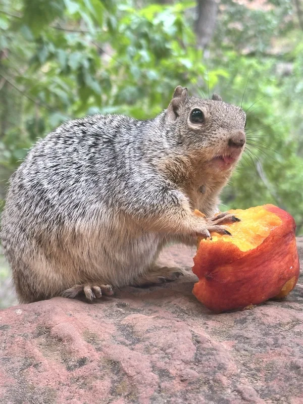
Rock Squirrel Otospermophilus variegatus -
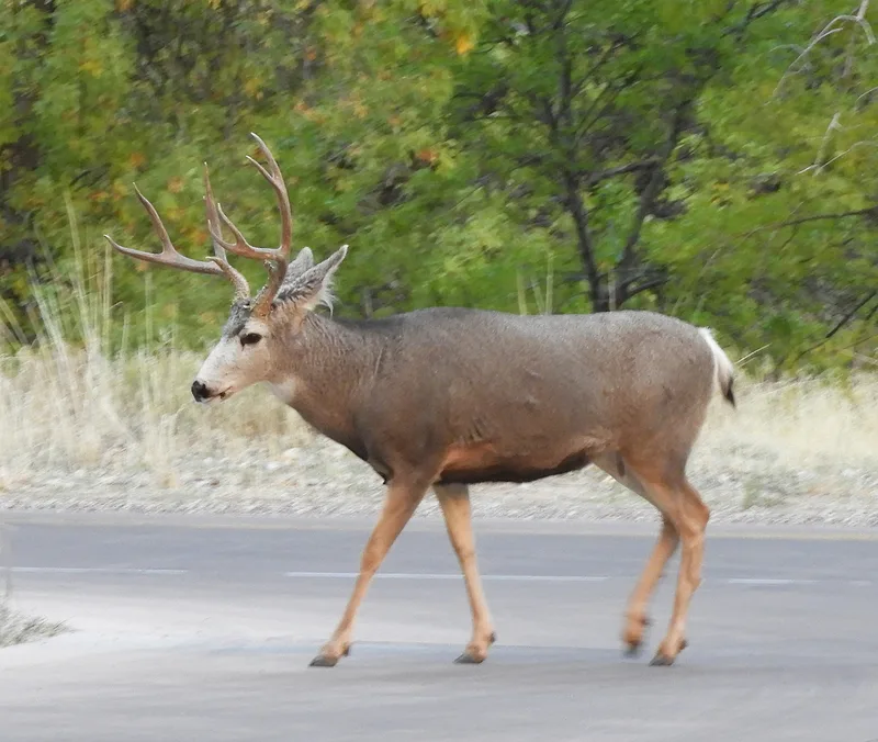
Mule Deer Odocoileus hemionus -
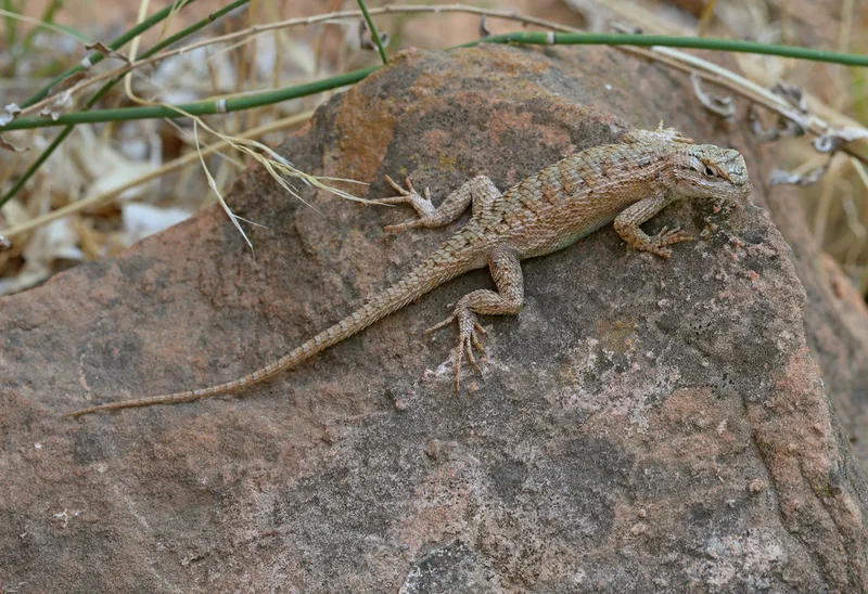
Plateau Fence Lizard Sceloporus tristichus -
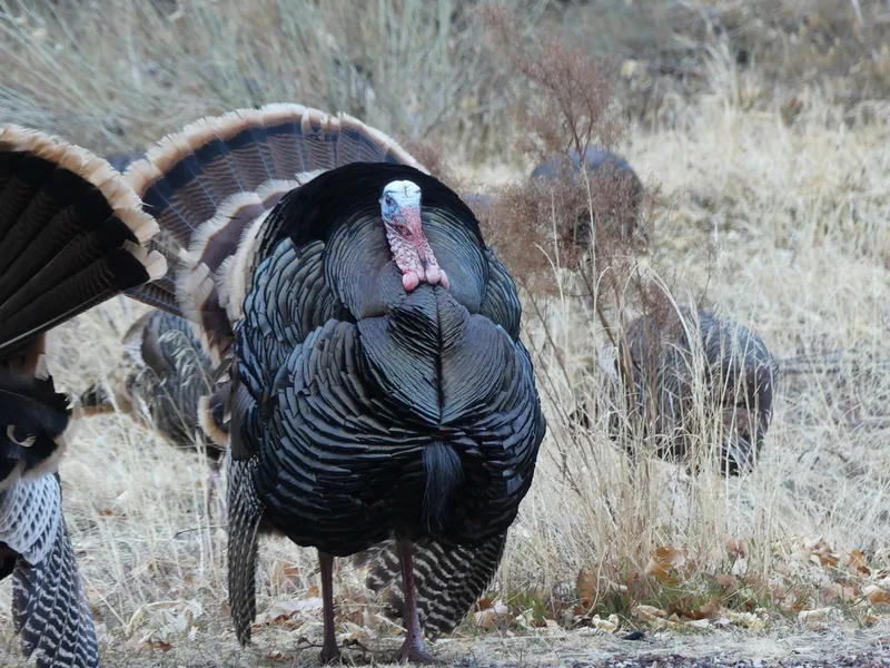
Wild Turkey Meleagris gallopavo -
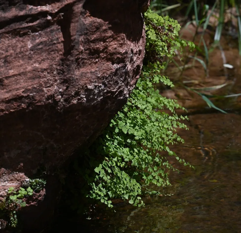
black maidenhair fern Adiantum capillus-veneris -
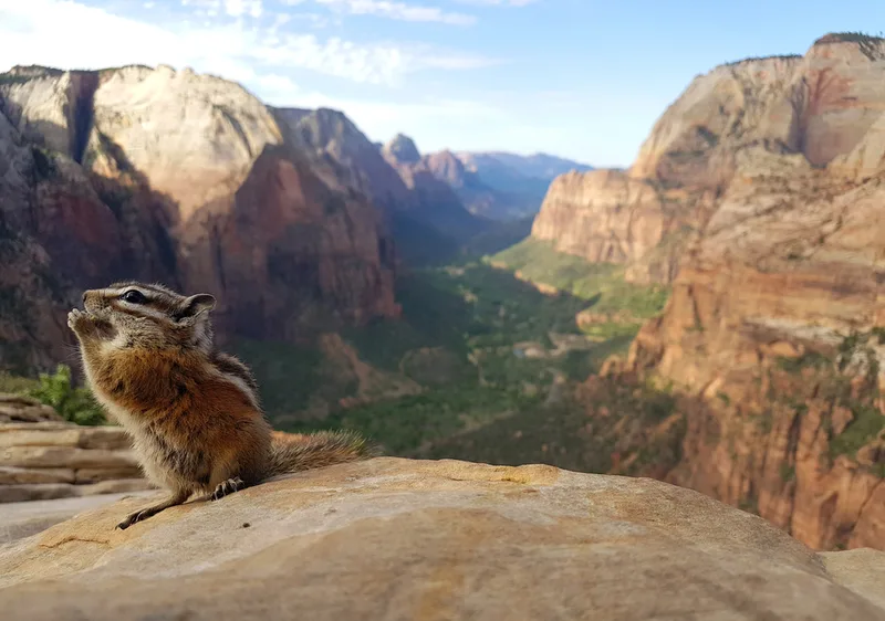
Uinta Chipmunk Neotamias umbrinus -
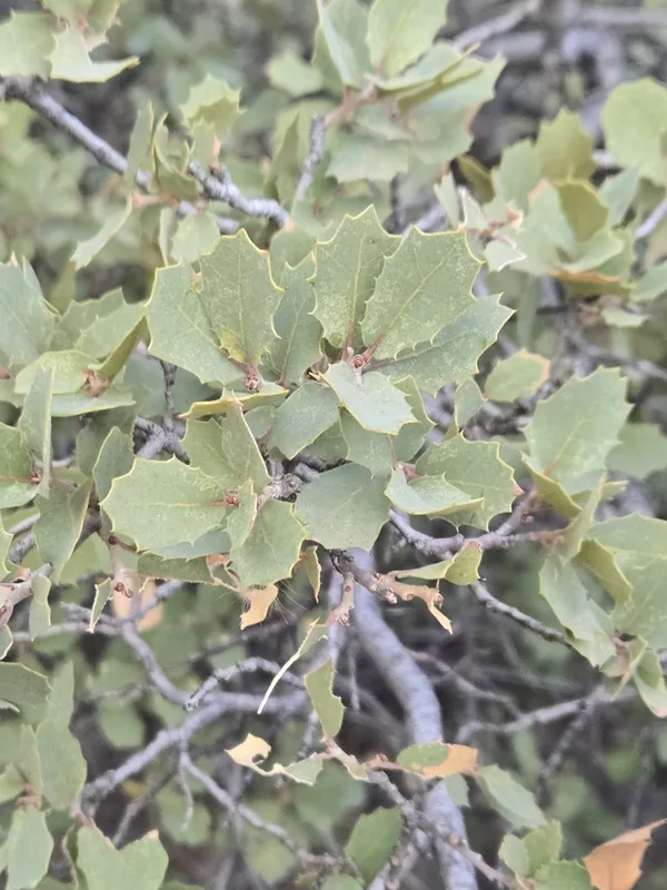
Sonoran scrub oak Quercus turbinella -
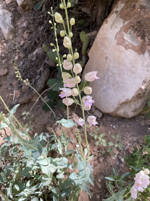
Palmer's penstemon Penstemon palmeri -
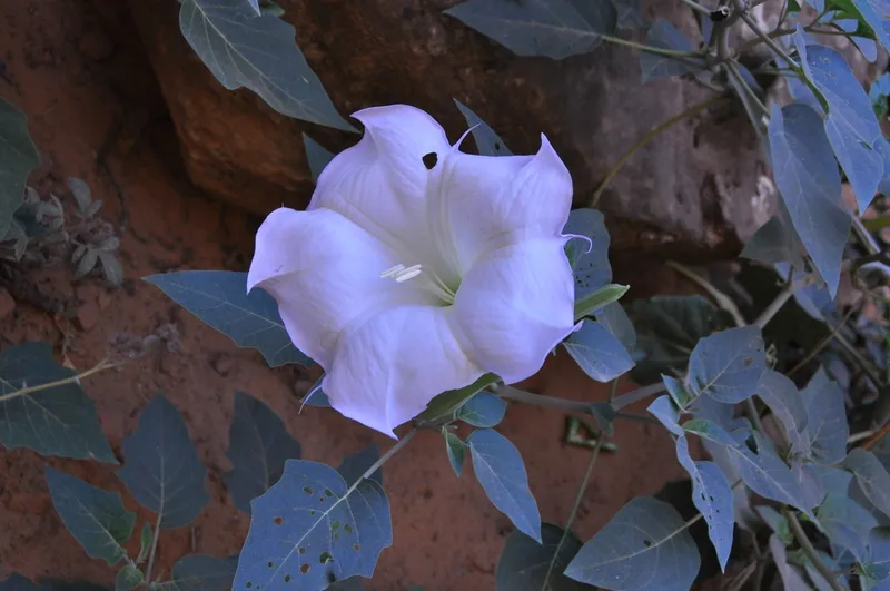
Sacred Datura Datura wrightii -
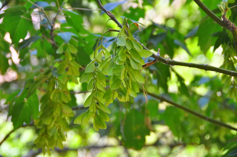
box elder Acer negundo -
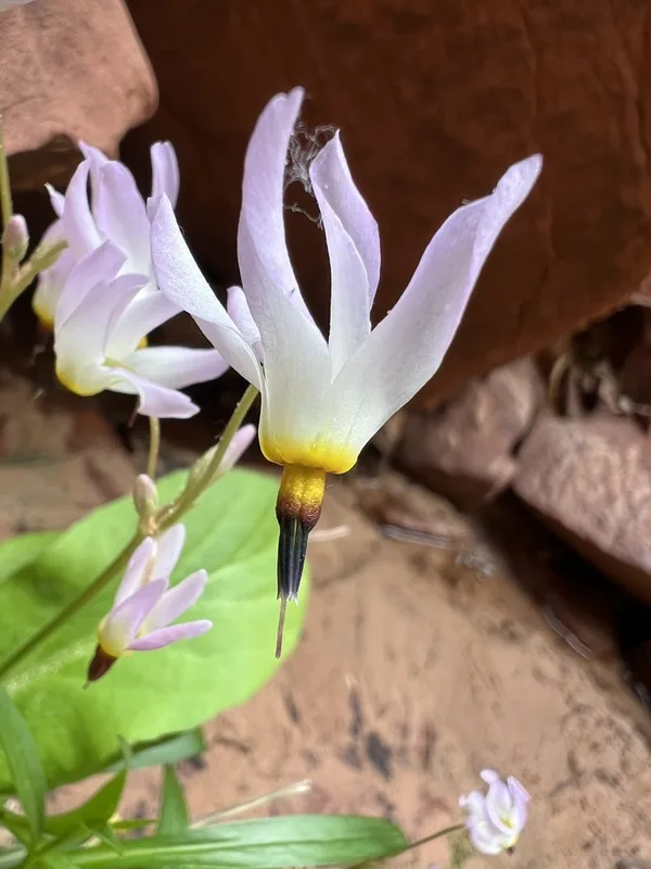
dark-throated shooting star Primula pauciflora -
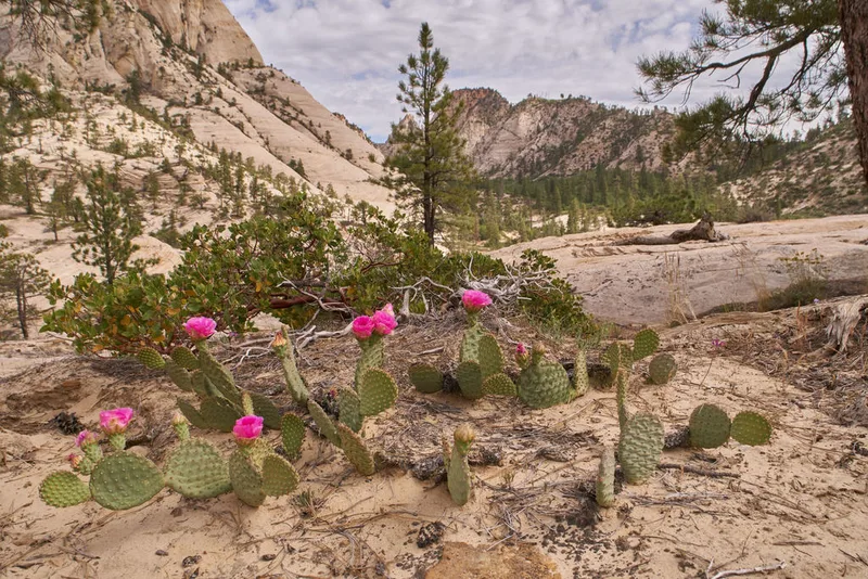
Golden Pricklypear Opuntia aurea
Field Notes · Rivers & Canyons lens · Zion Canyon · 37.2576, −112.9528