Point Lobos
Point Lobos State Natural Reserve · California, USA
The fog here is the same water that feeds it — risen cold from the deep, cooled into cloud, and settled back on the shore it shaped.
Also seen through Marine · all at Point Lobos State Natural Reserve →.
Why here
Some mornings the horizon simply disappears at Point Lobos. The ocean is there — you can hear it — but the whole Pacific vanishes behind a wall of grey that won’t lift until well past noon. That fog is not a separate weather event passing over the coast. It comes from the same water it hides. Along this shore, wind pulls cold water up from deep offshore, and where that cold water meets warmer, moist air above it, fog forms. The same rising water also carries nutrients up from below, feeding the open coast’s abundance — this stretch of sea and shore is counted among the richest stretches of marine habitat in California. Seals hauled on the rocks, cormorants working the swells, an urchin-crowded tide pool, wildflowers thick on the headland above the cliffs — all of it runs on the same cold current that keeps the fog coming back. The fog at Point Lobos is not gloom passing through. It is a sign of the sea doing its work just offshore, and reading it that way is what this whole trip keeps showing.
THESIS: Point Lobos’s fog and its rich sea share one cause — cold water rising from the deep, which cools the coastal air into fog and feeds the nearshore water into abundance.
The story
Long before there was fog to soften it, this coast was itself open sea floor — the sandstone, mudstone, and conglomerate under today’s cliffs settled here layer by layer on an ancient ocean bottom. Later, the shoreline itself rose, leaving flat shelves of gravel and sand stranded above the water they once sat under — the marine terrace that now carries trails and wildflowers. The sea never really left; it just kept working the edge of what used to be its own floor.
Life followed the water, not the rock. Cold, nutrient-rich currents off this point still draw harbor seals to the rocks and cormorants and pelicans to the swells above the reef, while the same fog that cold water makes keeps the coastal scrub on the terrace green through months when inland hillsides have already dried out — Douglas iris and blueblossom are usually thick on the slopes by spring.
People came for that same richness. Whalers worked this shore from a cabin that still stands near the water, drawn to a coast productive enough to support them; long after whaling ended, the same cold, food-rich water made this stretch a byword among divers along the Monterey Peninsula.
The sites
The cold water that makes the fog
Sea Lion Point
36.5180, −121.9520
Sea Lion Point puts you at the open edge of the reserve, looking straight into the water that explains almost everything else here. This is open ocean, not a sheltered cove, and the cold you feel coming off it is the same cold that pulls fog onto this headland on a still day. Harbor seals haul out on the rocks below, taking advantage of water rich enough to support them close to shore. Stand here at different hours and the light changes the story: fog thickening or thinning off the water as conditions shift. That rhythm is not random weather. It is the visible signature of cold water working against warm air, the same process that keeps this stretch of coast counted among California’s richest. Few places on the reserve make the connection between fog and food so directly available to a person just standing still.
Watch the water’s edge rather than the horizon. If a low bank of fog is sitting just offshore rather than over land, you’re looking at the cold current beneath it doing the work — the fog marks where the cold water is, almost like a shadow cast upward.
- AccessShort walk
- ExertionEasy
- TimeAn hour
Bird Island
36.5074, −121.9419
Bird Island sits just off the point, close enough to watch without a boat but far enough offshore to stay a refuge for the birds that use it. Brandt’s Cormorants and Brown Pelicans work the swells around it, diving into water cold and rich enough to keep them fed close to shore rather than far out to sea. The island is a good place to notice how much life a small patch of cold water can support: birds stacked on the rock, more working the air above, and often a low fog bank sitting just past the island itself, marking the cold water at its base. None of that abundance is separate from the fog that visitors sometimes complain about on an overcast day. It is the same system seen from two directions at once — one you can taste in the damp air, the other you can watch feeding in plain sight below.
Count how many kinds of seabird you can find working the water around the island in a few minutes, then look past them to the horizon. If fog sits low over the water beyond the island, that’s the same cold current feeding the birds in front of you.
- AccessShort walk
- ExertionEasy
- TimeAn hour
Point Lobos
36.5214, −121.9531
This viewpoint carries the reserve’s own name, and it earns it: a clear, uncluttered look at open ocean with nothing but water between you and the fog bank that so often sits offshore. From here the whole mechanism is visible at once — cold water below, damp air above it, cliffs and headlands catching whatever the two of them produce between them. On a clear day the view reaches out past the immediate coast toward the open Pacific, with nothing to break the line but distant swell; on a foggy one, the horizon can disappear behind a bank of grey instead. Either version of the view teaches the same lesson: the ocean in front of you is doing something, not just sitting there looking scenic, and the weather overhead is the visible proof of it.
Look for the line where clear air meets fog, whether it sits out at the horizon or right at the point. That edge marks roughly where warm air stops meeting cold water — move a little and watch how the line shifts.
- AccessShort walk
- ExertionEasy
- TimeAn hour
The land the fog keeps green
Whalers Knoll
36.5206, −121.9461
Whalers Knoll climbs just high enough to put the whole fog-fed slope in view at once. In spring the ground below carries Douglas iris and blueblossom in quantity, with paintbrush and seaside daisy filling the gaps between them and running down toward the water below. None of that color grows by accident on a headland this exposed to salt spray and steady wind. The same fog that blurs the view from up here also keeps these slopes damp and cool through the parts of the year when inland hillsides have already dried out and gone gold, letting a plant community persist here that could not survive the same exposure without that daily moisture. The knoll is a good place to stand still and let the two things in front of you, the flowers at your feet and the grey water beyond them, register as cause and effect rather than separate scenery.
From the knoll, look for where the coastal scrub gives way to bare rock or thin soil. The plants stop first where the wind is worst and the fog’s shelter runs out — a rough map of how far the fog’s protection actually reaches.
- AccessShort walk
- ExertionModerate
- TimeAn hour
Sand Hill
36.5175, −121.9511
Sand Hill sits on the marine terrace, the flat shelf of old sea floor that this coast lifted clear of the water over a long stretch of time. Stand here and two timescales come into view together: the ancient one, in the level ground underfoot that used to be seabed far below the surface, and the daily one, in the fog that still rolls up off today’s water to keep that old ground damp. The terrace’s soil holds enough moisture, thanks in part to that fog, to carry coastal wildflowers through stretches of the year when a similar slope further inland would already have gone brown and dormant for the season. It is a small, quiet demonstration of how a single ongoing feature, cold coastal fog, can keep working on a landscape long after the geological event that first built its stage is finished and gone still, shaping what grows here every single year that follows.
Run a hand across the ground cover here in the morning versus the afternoon. Fog-fed dew often keeps low plants damp well past sunrise here, longer than you’d expect a few hundred yards inland.
- AccessShort walk
- ExertionModerate
- TimeAn hour
A coast people worked for its richness
Cabin Trail
36.5190, −121.9403
Cabin Trail leads to Whalers Cabin, a building that has stood on this shore since people worked it for what the cold water offshore could provide them. The trail itself is short, but it is worth taking slowly: the same fog that can gray out the ocean view also settled over the people who once made a living from this coast, day after day, in a way that never fully lifted from their work or their thinking about the sea. Whaling here depended on a stretch of water productive enough to draw animals close to shore, the same richness that today draws seals, seabirds, and recreational divers rather than boats with harpoons out to open water. The cabin is a plain reminder that the connection between fog and abundance is not only a modern observation. People who worked this water for a living understood it as clearly as any weather sign they were given each morning.
Look for the cabin’s position relative to the water; it sits close enough to keep the sea in constant view. Consider what it would mean to read that fog every morning as a work forecast rather than scenery.
- AccessShort walk
- ExertionEasy
- TimeAn hour
Welcome to the Whale Trail
36.5156, −121.9480
This information board sits at the start of a stretch of coast known for what passes offshore, both visible and hidden from the trail underfoot. Above the water, migrating whales pass within sight of the point in their season; below it, reef fish like blue rockfish hold to the rocky bottom in water cold and rich enough to support them close to shore year after year. Both depend on the same current that also keeps fog visiting this headland through the year. The board is a small, fixed reminder that what a visitor notices first — gray sky, cold wind — is also exactly what a whale, a seal, and a diver are all responding to a few hundred yards away. Read it before heading out to any of the water-facing points nearby; it frames the rest of the reserve’s coast as one connected system rather than a series of separate views to collect.
Read the board, then walk to the nearest water-facing point and try to name three things — an animal, a plant, a rock feature — that the same cold water in front of you is responsible for.
- AccessDrive-up
- ExertionEasy
- TimeAn hour
When it's best
Fog is heaviest in the warmer months, when cool water offshore meets warm land air and keeps a marine layer parked over the headlands for much of the day — worth timing an early start around, before it burns off. Spring is the surer season for color: Douglas iris and blueblossom are usually near their peak by then, with coastal paintbrush and seaside daisy close behind. Harbor seals haul out on the rocks. Brown pelicans turn up here too, though less predictably.
Go deeper
The names behind what you saw. The shelf underfoot is marine terrace deposits — old sea floor lifted above the waterline. The older cliffs are Paleocene marine rocks: sandstone, mudstone, and conglomerate laid down when this coast was open ocean floor. The purple-flowered slope plant is Douglas iris, Iris douglasiana; the blue-flowered shrub is blueblossom, Ceanothus thyrsiflorus; the paintbrush is Monterey paintbrush, Castilleja latifolia; the animal on the rocks is harbor seal, Phoca vitulina; the diving black seabird is Brandt’s Cormorant, Urile penicillatus.
To read next. - Geological history of Point Lobos — the fuller account of the old sea floor and the lifted shelf underfoot. - Point Lobos (overview) — for more on why the offshore water here ranks among California’s richest, the same cold water that raises the fog. - Whalers Cabin — the human history of a coast worked because of that same richness. - Blue rockfish — one of the reef fish that thrives in the cold, food-rich water the fog signals from shore.
The payload’s syllabus list carries no dedicated further-reading set for this place; the readings above are drawn from its own source extracts instead.
The names behind what you saw
What lives here, and what it's called. Photographs from open collections — an aid to identification, not decoration.
-
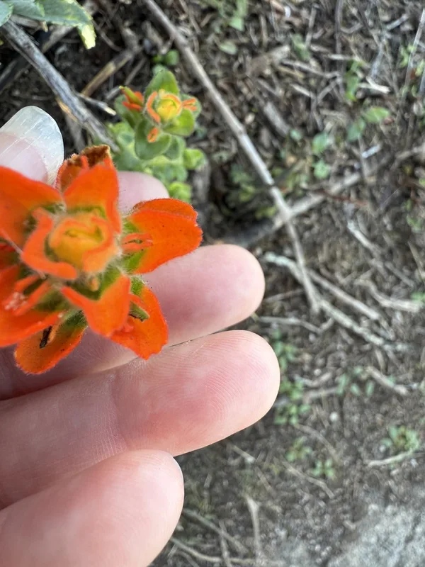
Monterey paintbrush Castilleja latifolia -
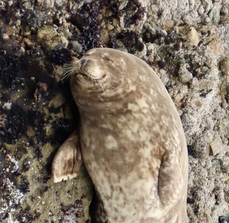
Harbor Seal Phoca vitulina -
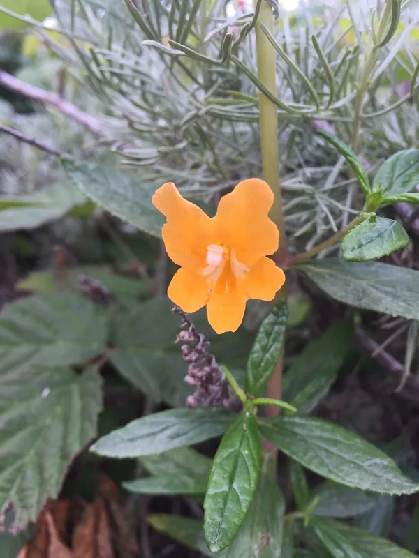
orange bush monkeyflower Diplacus aurantiacus -
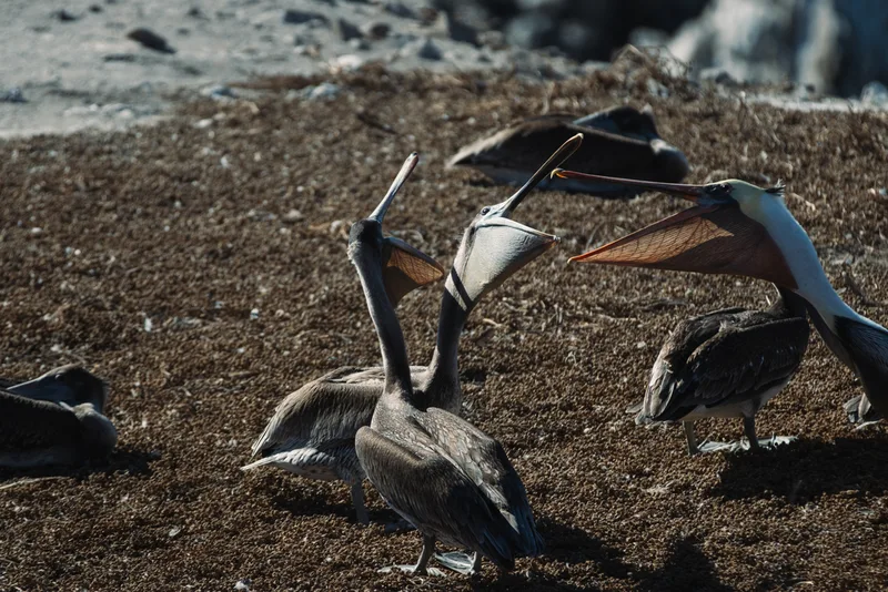
Brown Pelican Pelecanus occidentalis -
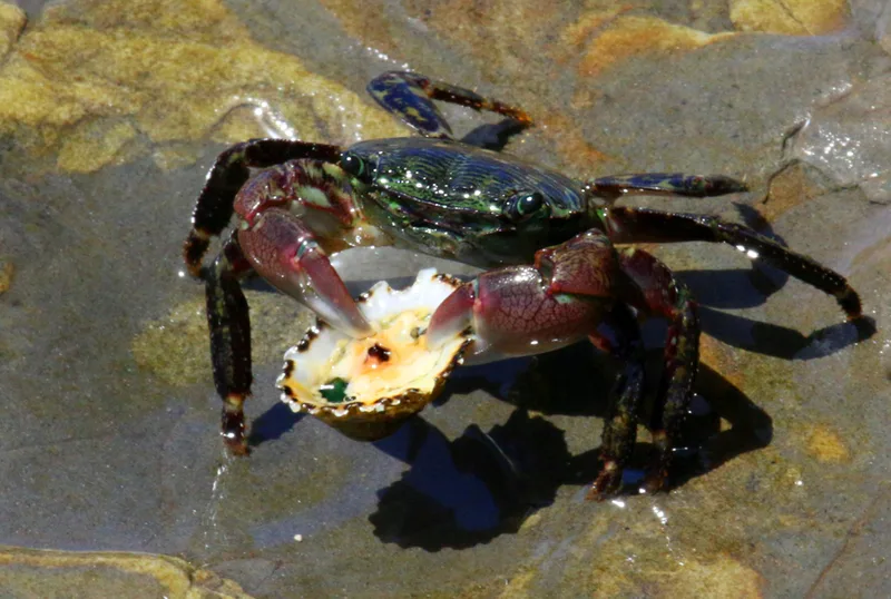
Striped Shore Crab Pachygrapsus crassipes -
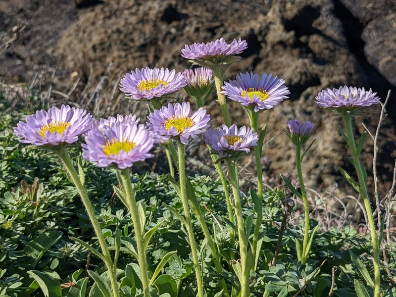
seaside daisy Erigeron glaucus -
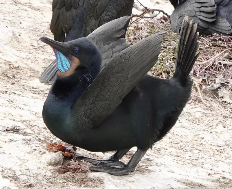
Brandt's Cormorant Urile penicillatus -
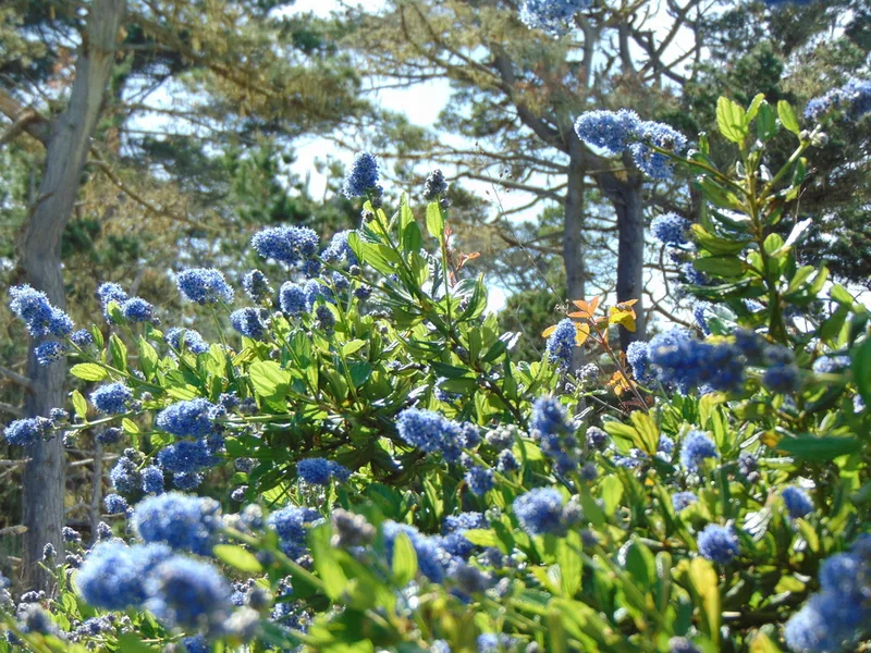
blueblossom Ceanothus thyrsiflorus -
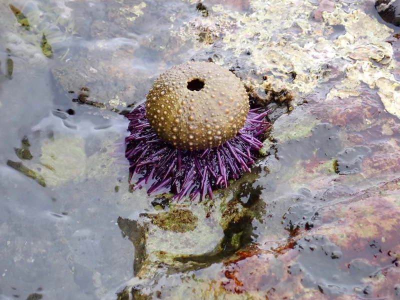
Pacific Purple Sea Urchin Strongylocentrotus purpuratus -
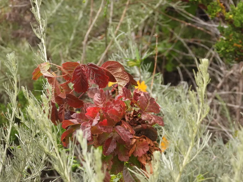
Pacific poison oak Toxicodendron diversilobum -
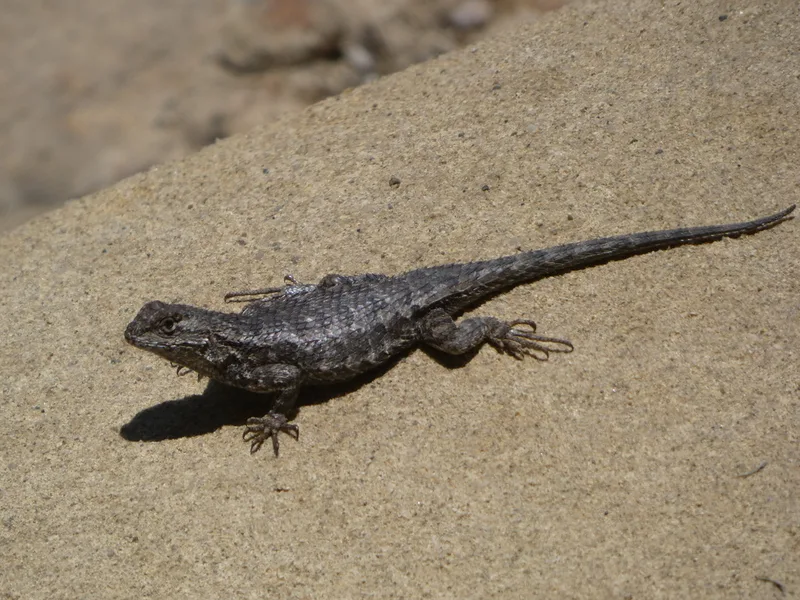
Western Fence Lizard Sceloporus occidentalis -
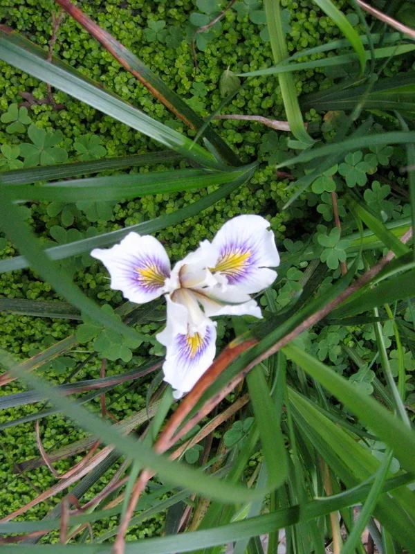
Douglas iris Iris douglasiana
Field Notes · Fog Coast lens · Point Lobos State Natural Reserve · 36.5147, −121.9428