The Olympic Coast
Olympic National Park · Washington, USA
On this coast the weather does not fall from the sky so much as roll in off the water.
Also seen through Marine · all at Olympic National Park →.
Why here
Stand on this coast on a summer morning and you can watch the land drink. A gray wall of fog slides in off the Pacific, catches in the tops of the big trees, and drips to the forest floor long after the last rain has gone. That fog is the whole secret of the place. The ocean here runs cold year-round, cold enough to wring water out of the air and hand it back to the forest through the dry months, which is why some of the wettest woods in the country grow within earshot of the surf. The same cold water does a second job. It carries food, and it keeps the low-tide rocks from cooking in the sun, so the tidepools fill with more life than bare stone should be able to hold. Forest and tideline look like separate worlds, but they run on the same engine — a cold sea breathing on the land. Read the coast that way and everything here, from a fern to a sea star, starts to make sense.
The story
Start with the rock. The headlands and stacks along this shore are dark gray sandstone, born as sand and mud on the floor of an ancient sea and later raised to stand in the surf. It is old seafloor, now taking the brunt of the waves.
Onto that raw coast came the fog. Cold water offshore feeds a near-constant summer mist, and the forest learned to live on it — tall evergreens along the shore, and inland, in the river valleys, the deep rainforest where moss loads every branch and sword fern, salal, and devil’s club crowd the ground. Turn over the wet litter and you meet a banana slug; in spring the white flower of a Pacific trillium opens in the shade. The cold reaches the water’s edge too, packing the low-tide rocks with ochre sea stars and green anemones.
People have mostly chosen to leave this stretch alone. The outer coast is one of Olympic National Park’s four regions, alongside the west-side rainforest, the high country, and the drier east — a thin wild strip kept whole where the land meets the sea. What holds it together is not the park boundary but the cold water just offshore, still doing the work it has always done.
The sites
Where the sea works the rock
Hoh Head
47.7682, −124.4762
Hoh Head is a high, forest-topped headland where the coast rears up out of the surf. Its dark sandstone is the same old seafloor that stands offshore in the stacks, hard enough to hold against waves that have worn the softer ground away. Reaching it means a wilderness walk along the beach, timed to the tide, but it shows the fog coast at full height — forested rock with the open Pacific below.
From the headland, look out to the stacks standing offshore. They are leftover pieces of the same hard sandstone you are standing on, left behind as the waves cut the coast back around them; watch one through a rising tide and the surf finds every weakness in the rock. Check a tide table before you start, since the beach route around the head only opens at lower water.
- AccessExpedition
- ExertionStrenuous
- TimeWorth two days
Salt Spray Forest (Beach 3) Nature Trailhead
47.6414, −124.3849
A short trail drops from the highway through a band of forest bent and thinned by salt wind, then opens onto a broad beach. At low tide the rock shelves here hold the fog coast’s tidepool life — ochre sea stars in purple and orange, and the fat domes of giant green anemones. It is the easiest place in this note to meet the cold sea’s tidepools face to face.
At low tide, crouch at the edge of a rock pool and find the giant green anemone — a soft blue-green column the size of a fist, open underwater like a flower. Its color comes partly from algae living inside it, fed by the same steady light and cold water that fill these pools with life; touch the rim gently and it slowly folds shut. Go on a low tide from a tide table, because the pools are underwater for most of the day.
- AccessShort walk
- ExertionEasy
- TimeHalf a day
The forest the fog feeds
Hoh River Trailhead
47.8605, −123.9344
This is the doorway to the Hoh, the valley that made this coast known for rain. Everything the ocean gives up as fog and storm collects here and grows into forest — evergreens tall enough to vanish into the mist, every trunk and fallen log furred with moss, sword fern and deer fern deep underfoot. Walk in a few minutes and the sound of the road is gone, replaced by dripping.
Stop on the trail, look up a single big trunk, then down to the ground around its base, and count the kinds of green growing on the tree itself — moss, ferns, seedlings rooted in the bark. This is a forest so wet it grows a second forest on its own branches, all of it watered by the ocean’s fog. Listen, too, for the long silvery song of a Pacific wren from the undergrowth.
- AccessDrive-up
- ExertionEasy
- TimeHalf a day
Kloochman Rock
47.6693, −123.9685
Kloochman Rock is a bare knuckle of stone standing above the forest in the Queets valley, one of the quieter rainforest drainages on this coast. The climb leaves the mossy bottomland and gains a viewpoint over a sea of treetops — the same fog-fed forest, seen from above instead of within. On a clear break you can trace how the green runs unbroken from the ridges down toward the sea.
From the rock, look out over the forest canopy and watch for fog. In the cool of morning it often lies in the valley bottoms in long white fingers, following the rivers inland from the coast. That is the ocean’s moisture moving upstream, the daily delivery the whole forest below you lives on.
- AccessExpedition
- ExertionStrenuous
- TimeWorth two days
Colonel Bob Peak Trailhead
47.4967, −123.7936
The trail to Colonel Bob starts low in the rainforest along the coast’s southern edge before climbing hard toward the peak. The first stretch is the fog forest at its lushest — salmonberry and salal thick along the path, devil’s club guarding the wet draws. It is a place to feel how much life the cold-sea climate packs into the lowest, warmest corner of this coast.
Along the lower trail, find devil’s club — a broad-leaved plant on a thick, spiny stem, often shoulder-high in the wettest ground. It grows where water never stops moving, so a stand of it marks a seep or a spring underfoot. Give the spines room, since they catch.
- AccessHalf-day hike
- ExertionModerate
- TimeHalf a day
The fog's inland reach
Mount Octopus
47.7490, −124.1777
Mount Octopus is a low, forested summit set back from the shore between the Hoh and the Queets, deep in the western foothills. Nothing here rises high enough to escape the marine air, so the same coastal forest that lines the beaches climbs right over it. It marks how far inland the coast’s climate reaches before the country begins to change.
From anywhere on the slope, notice how thick the moss hangs and how little bare bark shows on the older trees. Even miles from the surf, the trees wear the coast on them — the fog that started over the ocean settles here too, and the forest keeps it. Run a hand over a north-facing trunk and feel how wet the moss stays even in dry weather.
- AccessExpedition
- ExertionStrenuous
- TimeWorth two days
Reade Hill
47.8901, −124.2958
Reade Hill is a modest rise in the low country near the coast, close enough to the shore that the fog reaches it early. Forest covers it like everything else here, but its low ground makes it an easy place to watch the marine air arrive rather than chase it into the high valleys. The land near the sea is where the fog coast begins its work each day.
On a summer morning, watch the tops of the trees for drifting fog. Here near the coast it comes early and often, snagging in the canopy and dripping down — the first step in how the ocean waters this whole forest. Stand still a minute and you may hear it fall like light rain under the trees, even with a clear sky above.
- AccessExpedition
- ExertionModerate
- TimeHalf a day
Geodetic Hill
47.8548, −124.1213
Geodetic Hill is another of the low western summits, its name a nod to the surveyors who once used such high points to map the country. Like its neighbors it stands well within reach of the sea fog, cloaked in the same wet forest. The interest here is less the summit than the living floor beneath it.
On the forest floor, look for the ferns that carpet the ground between the trunks — sword fern in tall arching clumps, and the smaller deer fern lower down. They thrive in the steady damp the fog keeps up all summer, which is why the ground is green even when the sky is not. Listen for the ringing, one-note call of a varied thrush somewhere in the trees.
- AccessExpedition
- ExertionModerate
- TimeHalf a day
When it's best
The coast keeps two calendars. Summer is fog season — mornings often start gray and close, the sun burning through by midday if it comes at all — and this is when the forest does its quiet drinking and the woods stay cool and green. Winter swings the other way, into long stretches of Pacific rain and heavy surf, when the rivers run high and the rainforest is at its most saturated. The tidepools answer to the moon rather than the season: the lowest tides, which bare the most rock and the most life, cluster around the new and full moon, so for tidepooling a tide table is worth more than a forecast. Any time of year the forest floor is green, but spring brings the understory into flower and the migrant birds back into the canopy.
Go deeper
The dark coastal sandstone is the Hoh Formation, a body of marine graywacke — search that name for how the Olympic rock was built from old seafloor. In the tidepools, the ochre sea star is Pisaster ochraceus, the giant green anemone Anthopleura xanthogrammica, and the smaller clonal one the aggregating anemone, Anthopleura elegantissima. On the forest floor, the banana slug is Ariolimax columbianus; the ferns are western sword fern (Polystichum munitum) and deer fern (Struthiopteris spicant); the spiny understory shrub is devil’s club, Oplopanax horridus, growing beside salal (Gaultheria shallon), salmonberry (Rubus spectabilis), and Pacific trillium (Trillium ovatum). The one-note forest bird is the varied thrush, Ixoreus naevius; the small loud singer is the Pacific wren, Troglodytes pacificus.
- R. W. Tabor, Guide to the Geology of Olympic National Park (1975) — the friendly field introduction to how these rocks came together.
- R. W. Tabor, Geology of Olympic National Park (1987) — a fuller treatment of the same ground.
- Geologic Map of the Olympic Peninsula, Washington (1978) — the map that lays out where each rock unit meets the coast.
- “Geological Reconnaissance of the Coast of the Olympic Peninsula, Washington” (1906) — an early walk-the-shore survey of this exact coastline.
The names behind what you saw
What lives here, and what it's called. Photographs from open collections — an aid to identification, not decoration.
-
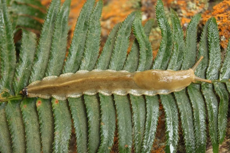
Pacific Banana Slug Ariolimax columbianus -
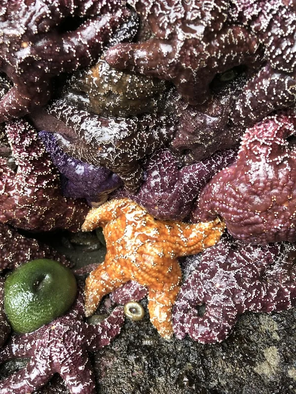
Ochre Sea Star Pisaster ochraceus -
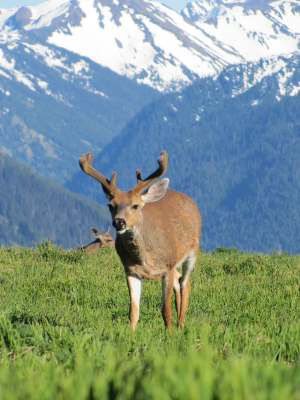
Mule Deer Odocoileus hemionus -
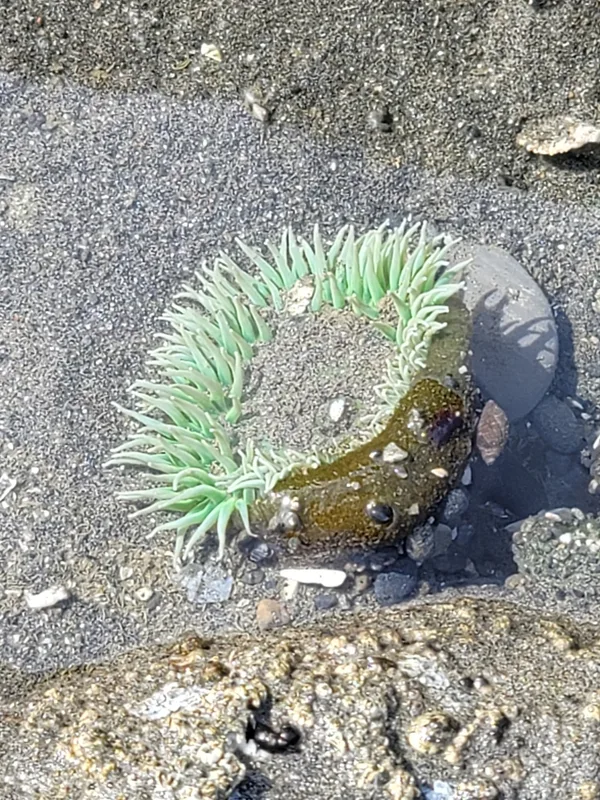
Giant Green Anemone Anthopleura xanthogrammica -
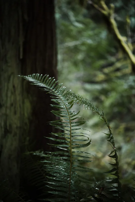
western sword fern Polystichum munitum -
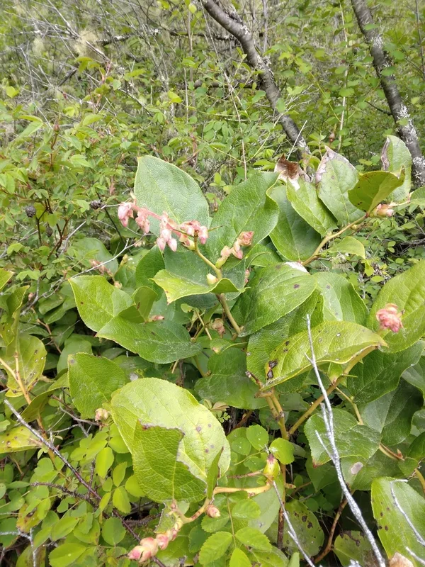
salal Gaultheria shallon -
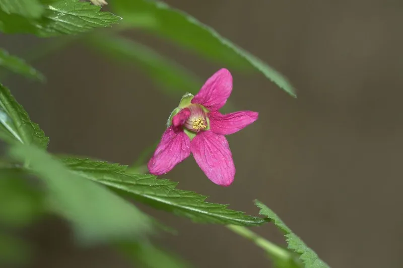
Salmonberry Rubus spectabilis -
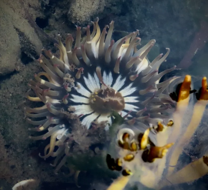
Aggregating Anemone Anthopleura elegantissima -
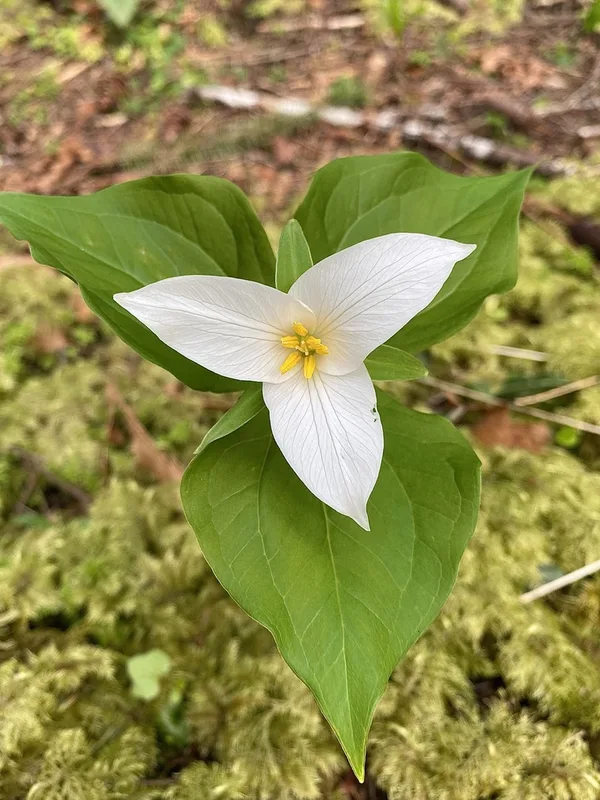
Pacific trillium Trillium ovatum -
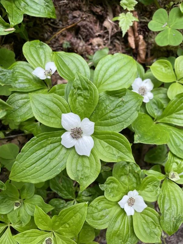
Western Bunchberry Cornus unalaschkensis -
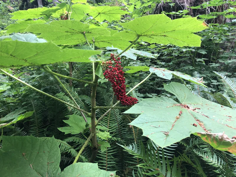
Devil's Club Oplopanax horridus -
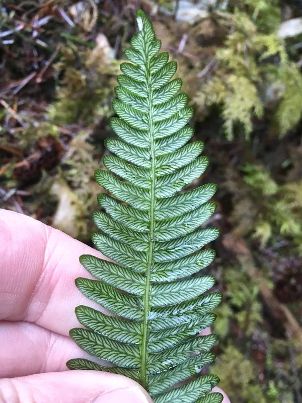
deer fern Struthiopteris spicant
Field Notes · Fog Coast lens · Olympic National Park · 47.7865, −123.5360