Uluṟu-Kata Tjuṯa
Uluṟu-Kata Tjuṯa · Northern Territory, Australia
The desert here has worn through to the page underneath, and left it lying open.
Why here
Stand at the base of either rock and you are looking at exposed history — no soil, no forest, nothing hiding it from you. Most landscapes bury their story under a skin of dirt and green; this one has worn straight through to the rock beneath. Uluṟu and Kata Tjuṯa are not simply large rocks in a flat desert — they are what is left after almost everything softer around them wore away, grain by grain, over a span of time so long it makes the desert itself look young. What survived tells you what the country used to be, and it survived precisely because it was harder than everything that used to sit beside it. Walk here with that single fact in mind and the landscape stops being a backdrop for a photograph and starts reading like a cross-section: bedrock at the bottom of the page, young red dune sand freshly written on top, and two stubborn chapters of solid rock refusing to be erased. This note keeps returning to that same idea — what stayed, and why.
The story
The rock underfoot began as ordinary sediment, laid down in layers over an immense stretch of time, then buried, compressed, and hardened into stone long before anything alive walked over it. Later, nearly all of that stone was stripped away again — worn down grain by grain until the country flattened into the desert plain you see today. Uluṟu and Kata Tjuṯa are what refused to go: two remnants, shaped differently at depth, left standing while everything softer around them disappeared. Even now the process has not finished; fresh red dune sand, geologically far younger than the rock itself, keeps drifting in around their bases and slowly reshaping the ground at their feet.
Life took hold wherever the desert offered a foothold. Desert sheoak roots anchor the shifting dune sand well enough to keep it from blowing away entirely. Reptiles such as the Long-nosed Dragon and Central Netted Dragon use the sun-warmed rock itself as a source of heat they cannot make on their own. Honeyeaters and finches move through wherever shade and water gather at the rock’s base.
People have made their home in this country for a very long time, and continue to. Mutitjulu, a community named for a rock-hole at Uluṟu’s base, sits within the park; its residents are traditional owners who now jointly manage the land with Parks Australia. The Aboriginal land trusts bordering the park to the south belong to Pitjantjatjara, Yankunytjatjara, and Luritja people, whose country this has long been.
The sites
Two shapes, one long argument
Uluṟu
−25.3449, 131.0325
Uluṟu is a single block of sandstone rising clear out of flat desert, with nothing in the surrounding country tall enough to compete with it. That isolation is the whole point: almost everything that once surrounded this rock has worn away to nothing, grain by grain, over a stretch of time so long that the desert around it looks freshly made by comparison. What is left is simply what was too hard to lose. Walk the base and the rock changes character constantly — smooth swept faces give way to deep vertical grooves, shallow caves, and rounded overhangs, each shaped by water finding the weakest line in the stone and following it down. The rust-red color comes from iron in the rock reacting with the air over a very long time, a slow weathering that only reaches a thin skin of the surface — crack the rock open and the stone inside is a paler grey. None of this is finished: rain still runs the same grooves after a storm, and the surface is still very slowly losing ground to the same weathering that carved everything you can see. You are looking at one long, unfinished argument between hard rock and patient water, still being fought in real time.
Walk a stretch of the base and look closely at the rock face for dark vertical streaks running down from ledges and hollows — these are mineral stains left by rainwater draining the stone after storms; trace one from where it starts to where it fades and you are watching, in miniature, the same process that shaped the whole rock.
- AccessShort walk
- ExertionModerate
- TimeHalf a day
Kata Tjuṯa
−25.2979, 130.7336
Where Uluṟu is one continuous block, Kata Tjuṯa is more than two dozen domes standing shoulder to shoulder, separated by narrow gorges instead of holding together as a single face. Geologists mapping this landform call it a bornhardt — the general name for a rounded, steep-sided rock dome that survives while the softer country around it wears away. The domed shape itself is a clue: weathering attacks the corners and edges of a rock mass fastest, rounding it down over time the way a bar of soap rounds under a running tap, until what is left tends toward a dome rather than a block. Multiplied across dozens of separate high points instead of one, the effect here is a cluster rather than a monolith — the same underlying process as its neighbor to the east, a different result, because the rock itself is built differently at depth. Stand back and take in the whole group rather than any one dome; the pattern across all of them, not any single face, is what tells the geological story. The gaps between the domes are as informative as the domes themselves — each is a valley where water has spent a very long time finding and following the weakest seams in the stone.
From a distance, count the separate domes you can see and notice how each rises to a rounded rather than a pointed or flat top; that consistent rounding, repeated across every dome, is the signature of long, even weathering working equally on every exposed face.
- AccessShort walk
- ExertionModerate
- TimeHalf a day
Distance shows the shape time carved
Talinguru Nyakunytjaku Sunrise Viewpoint
−25.3676, 131.0639
This viewpoint sets Uluṟu at a distance, low over the plain, which turns out to be the best way to actually see its shape. Close to the rock, you see wall; from here, you see form — the long, gently undulating silhouette, higher at one end than you might expect, with none of the sharp angles a person might picture before seeing it in person. Morning light rakes low across the stone at this hour, which does more to reveal the surface than the strongest midday sun ever could: shallow grooves, rounded ridges, and old drainage lines that stay flat and hard to read at noon suddenly throw shadows and stand out in relief. The surrounding plain, low scrub and red sand stretching flat in every direction, does real work here too — it is the visible baseline for how much material has been stripped away everywhere except where the rock now stands. Nothing between you and the horizon rises to challenge it. That contrast, more than any single detail on the rock itself, is what makes the scale of the erosion legible: an entire landscape reduced to flat country, but for the one shape too stubborn to go with it.
As the light changes, watch how shadows move across the rock’s surface and pick out grooves and ridges invisible in flatter light; return later in the day if you can, and the same rock will look like a different shape entirely.
- AccessDrive-up
- ExertionEasy
- TimeAn hour
Uluru Lookout
−25.2478, 130.9896
From here Uluṟu sits well out on the plain, distant enough to disappear into haze on a hot afternoon and reappear sharp-edged in cooler, clearer air. What this distance gives you is scale without distraction: no foreground detail competes with the plain fact of one large rock standing alone over flat country that runs, visually, all the way to the horizon in every direction. That isolation is not scenery, it is evidence — it tells you plainly that whatever used to fill this country between here and the rock has gone, worn down to the same low, flat desert you are standing on, while the rock itself simply held its ground. From this far back the eye reads the whole shape at once rather than any one face or texture, and the shape itself is worth studying: a long, humped outline, not a single peak, wider and lower than most first-time visitors expect from photographs taken up close. Come at different times of day if the trip allows it; the color shifts from ochre to a deep, almost bruised red as the sun drops, purely a matter of how much atmosphere the light passes through, with nothing about the rock itself changing at all.
Look along the horizon in every direction and note how little else breaks the flat line of the plain; that emptiness is the visible record of everything that once stood here and has since worn away, leaving only what you see ahead of you.
- AccessDrive-up
- ExertionEasy
- TimeAn hour
Kata Tjuta Viewing Area
−25.3002, 130.7362
This is the place to take in Kata Tjuṯa as a group rather than as individual domes — the whole cluster laid out together against the sky, close enough to read texture but far enough back to see the pattern across all of it at once. Look for the way the domes step down in height rather than standing at one uniform level; some rise well above their neighbors, a reminder that even resistant rock is not uniformly resistant, and that weathering has worked unevenly across the whole formation over a very long time. The valleys between domes are narrow and steep-sided rather than broad, which tells you something too: water moving through this country has tended to cut down rather than spread out, following the same lines again and again rather than wandering. Early or late in the day, the low light picks out the separation between domes far better than the flat glare of midday, when the whole cluster can read as a single indistinct mass. Give this one more than a passing glance; unlike a single monolith, a formation built from dozens of separate high points rewards slow, comparative looking — one dome against the next, rather than one dome alone.
Pick two domes of clearly different heights and follow the valley between them down to its lowest point; that low point is where water has cut deepest and longest, and it usually marks the weakest seam in the rock.
- AccessDrive-up
- ExertionEasy
- TimeAn hour
Close to the rock, close to the record
Karingana Lookout
−25.2920, 130.7417
Karingana sits close enough to Kata Tjuṯa’s domes to trade the wide view for texture: rock face right in front of you, streaked, pitted, and cut by narrow gorges rather than seen whole from a distance. This closeness is also what makes the site good for watching how the desert actually uses bare rock, not just how it looks. Exposed stone in full sun heats quickly and holds that heat well into the morning, which is exactly the resource local reptiles rely on. Central Netted Dragons and Long-nosed Dragons both turn up on sun-facing rock like this, using it as a source of warmth their own bodies cannot generate — a simple, ancient trade between an animal that needs heat and a surface built to store it. Look low on the rock rather than up at the skyline; that is where the activity is. The gorge itself narrows and deepens the closer you get to its head, another small piece of the same water-following-the-weak-seam pattern visible everywhere in this rock group, just easier to read at close range than it is from the wider viewing areas.
In the morning, scan the sun-facing rock low to the ground for a small lizard holding still, often angled to catch the most direct light; it is using the warmed stone the way you might use a blanket, and will not move until it has taken on enough heat to be active.
- AccessShort walk
- ExertionModerate
- TimeAn hour
Kata Tjuta Dune Viewing
−25.3510, 130.7869
This stop looks past the domes to the ground they are rising out of: low red dunes and sandplain, mapped separately from the rock itself because it belongs to a completely different, much younger chapter. The domes are old, weathered survivors; the sand at their feet is new and still moving, built from wind-blown grains that continue to shift and resettle rather than sitting fixed the way the rock does. Desert sheoak, a hardy tree suited to loose sand, is one of the plants doing the work of holding these dunes in place — its roots anchor the surface enough that wind cannot simply carry the whole dune away, even as sand keeps arriving from elsewhere and burying what came before. The contrast is the whole point of the stop: ancient, static rock in the near distance, young, restless sand at your feet, both part of the same view but running on entirely different clocks. Nothing here is dramatic to look at in the way a rock face is, which is exactly why it rewards a slower look — the dune is quietly doing, right now, in real time, what the rock finished doing long ago.
Find a sheoak or similar shrub rooted into the dune slope and look at how sand has built up or blown away immediately around its base compared to open sand nearby; the difference shows you, in miniature, how a single rooted plant can hold ground against a moving dune.
- AccessDrive-up
- ExertionEasy
- TimeAn hour
When it's best
This is desert country, and the honest seasonal note is about extremes rather than a single best window: days run hot for much of the year, nights fall away cold, and rain is rare enough that a decent shower changes the color and smell of the place for a day or two afterward, then fades back to dry. Cooler months make walking around the rock bases far more comfortable and tend to bring clearer air for long-distance views like the ones from the outer lookouts, when haze on a hot afternoon can soften the rock’s edges from a distance. That said, the rock and its domes are not a seasonal spectacle so much as a permanent one — the geology reads the same in any month, and a still, clear morning at almost any time of year is enough to see it well.
Go deeper
The names behind what you saw - Uluṟu — described in the sources as a large sandstone monolith. - Kata Tjuṯa — mapped as a bornhardt, the general geological term for a rounded, steep-sided residual rock dome. - The old rock underfoot is mapped as Neoproterozoic-to-Ordovician sedimentary rock — laid down somewhere between roughly a billion and about four hundred forty million years ago. - The dune country wrapping the rock’s base is mapped separately, as much younger Cenozoic-to-Quaternary dune and sandplain deposits. - Long-nosed Dragon (Gowidon longirostris) and Central Netted Dragon (Ctenophorus nuchalis) — the rock-baskers. - Desert sheoak (Allocasuarina decaisneana) — the dune-anchoring tree.
To read next - Wikipedia, “Uluru” — the clearest short account of the monolith itself and its dual naming. - Wikipedia, “Uluṟu-Kata Tjuṯa National Park” — orients both rock groups within the wider protected landscape. - Wikipedia, “Mutitjulu” — the community at Uluṟu’s base and its joint-management arrangement with Parks Australia. - Wikipedia, “Katiti Aboriginal Land Trust” — the Aboriginal-owned land trust bordering the park, for readers curious about the wider country around it.
The names behind what you saw
What lives here, and what it's called. Photographs from open collections — an aid to identification, not decoration.
-

Crested Pigeon Ocyphaps lophotes -

Yellow-throated Miner Manorina flavigula -
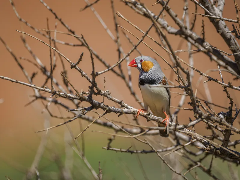
Zebra Finch Taeniopygia guttata -
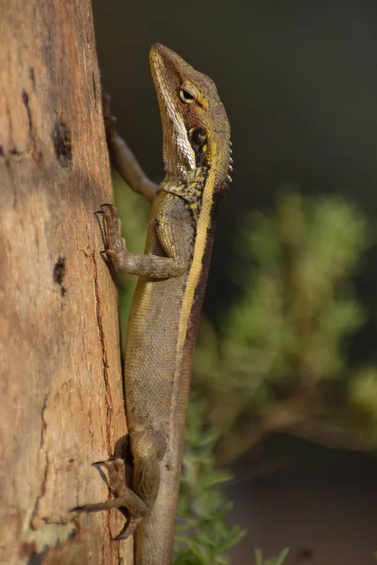
Long-nosed Dragon Gowidon longirostris -
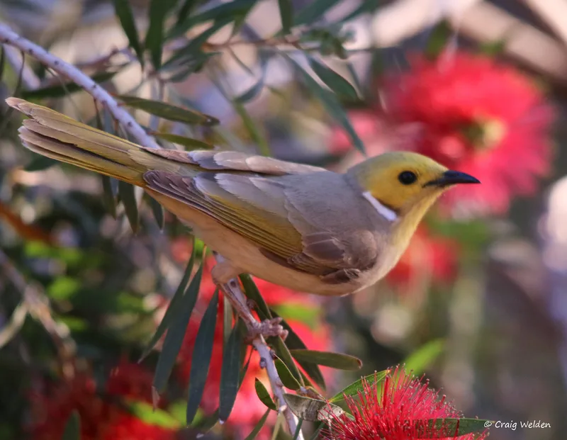
White-plumed Honeyeater Ptilotula penicillata -
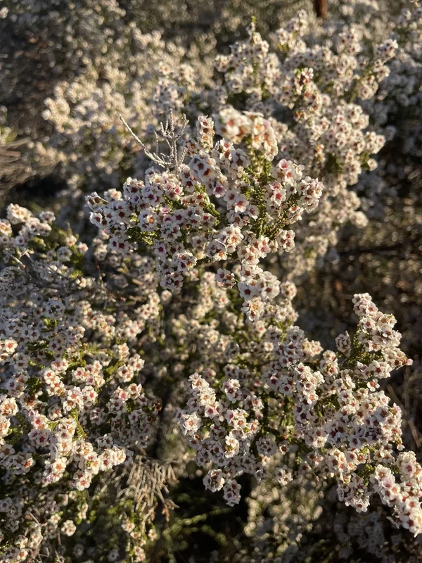
Desert heath myrtle Aluta maisonneuvei -
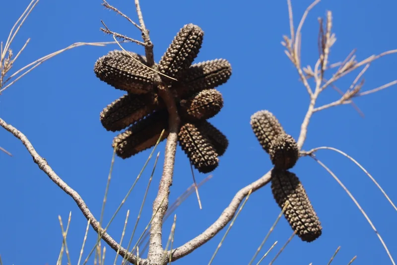
desert sheoak Allocasuarina decaisneana -

Central Netted Dragon Ctenophorus nuchalis -
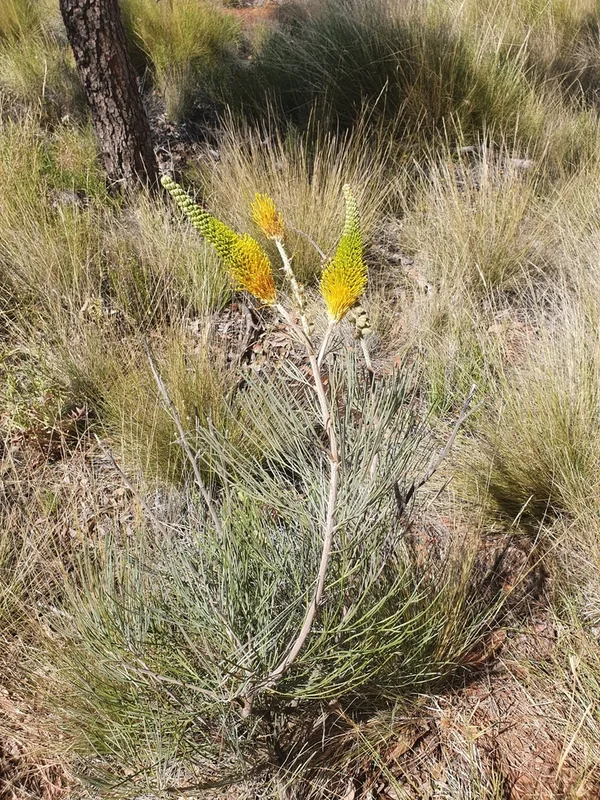
yellow flame grevillea Grevillea eriostachya -
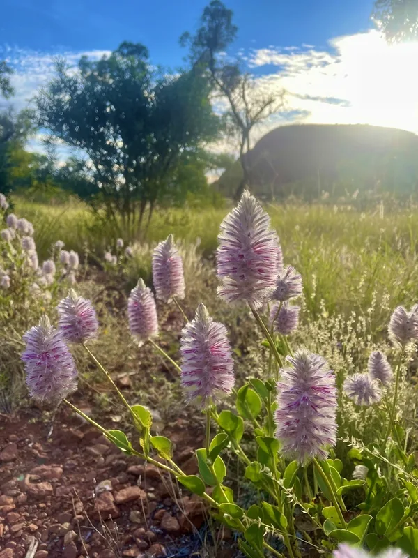
Pink Mulla Mulla Ptilotus exaltatus -
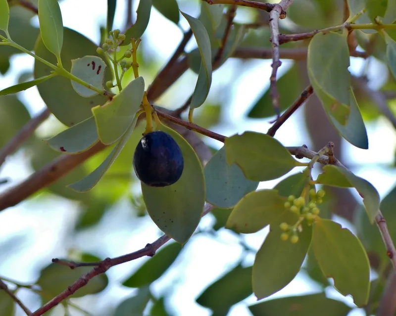
Blue Bush Santalum lanceolatum -
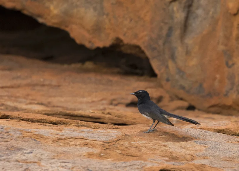
Willie Wagtail Rhipidura leucophrys
Field Notes · Desert & Deep Time lens · Uluṟu-Kata Tjuṯa · −25.1950, 130.7083