The Mendocino Coast
Mendocino Headlands State Park · California, USA
On this coast the summer rain comes as fog, and the forest drinks it down.
Why here
The greenest season on this coast can arrive without a drop of rain. Through the dry months, cold water rises along the shore and chills the air above it into fog, and that fog drifts inland each night to bead on every needle and leaf. What runs off is a slow, gray rain the sky never sends — enough to carry a forest through a summer that would otherwise burn it brown. This is a coast the sea keeps alive. You can read the arrangement on the ground: the banana slugs crossing the trail, the small salamanders under the bark, the low weave of sorrel and trillium — all of them things that live only where the ground never dries. The rock beneath them is old sea floor, scraped up and lifted into the flat benches you now walk on. The sea built this land, then stayed close enough to water it. Everywhere you go here, look for the same quiet exchange: the ocean handing the shore what the weather withholds.
The story
Start with the rock. The cliffs and the flat land behind them are old sea floor — sandstone and mudstone scraped off the descending ocean bottom and jammed against the edge of the continent. Earthquakes have since lifted that jumble in slow pulses, leaving a set of level benches stepping back from the water like a shallow staircase, each one a former beach raised out of reach of the waves.
On top grows the forest the fog keeps alive. In its shade stand Pacific rhododendron, evergreen huckleberry, and salal; the floor is a low carpet of redwood sorrel and, in early spring, the three white petals of trillium. The damp itself has residents — fat banana slugs and small woodland salamanders that never stray far from moisture. Offshore, the same cold water that makes the fog feeds the birds: cormorants, guillemots, and oystercatchers work the rocks and stacks.
Then the people, late and hungry for wood. A town rose on the bluffs and was built largely of the coast redwood growing behind it — even its tall-steepled church is redwood. The record here is quiet on who lived on this coast before the mills and the ranches; that story sits mostly outside these pages, and it is the sea and the forest, not the settlers, that this note keeps returning to.
The sites
The edge where the sea works the land
Mendocino Headlands State Park
39.2971, −123.7209
The bluffs wrap almost entirely around the town — a broad apron of open headland, sea-cut islets, and two beaches, all held as parkland rather than built over. It is the plainest place to meet the whole idea of this coast in a single walk. The flat ground you cross is an old sea floor, lifted clear of the waves by long centuries of earthquakes, and the wind coming off the water is the same cool, wet air that keeps the forest inland green through a rainless summer. Out on the most exposed rock, low cushions of lavender seaside daisy hold their grip where little else will, and the offshore stacks give nesting seabirds a foothold the mainland cannot — cormorants and their kin work the water below. Trails run right along the edge, with the town’s tall-steepled redwood church standing back from the bluff. Keep well back from the crumbling lip; the same softness that lets the sea cut these islets is eating the edge you stand on.
Walk to the bluff edge and stand on the flat, level ground. Notice that it ends in a sharp drop to the water rather than sloping down to it — this bench is a former beach, lifted out of the sea and left high and dry. Then look inland for a second, higher flat standing behind it; each level is a separate lift.
- AccessDrive-up
- ExertionEasy
- TimeHalf a day
Bridgeview
39.3296, −123.8077
A marked pullout near the north edge of the region, set where the road opens to a wide look over the coast. There is nothing built here and nothing to pay — just a place to stop and read the water. It is a good vantage on the one mechanism the whole note turns on: the cold ocean below, and, on many days, the fog that ocean breeds sliding low over its own surface. From a height like this the fog often shows itself as a distinct gray ceiling lying flat on the sea, sea-level cloud that never climbs far into the sky. That same damp, once the afternoon cools, will drift over the shore and settle into the forest by nightfall. Come on a clear day and you get the coastline’s shape instead — the points and coves where hard rock resists the waves and softer rock gives way.
On a gray day, look out to sea and find the top edge of the fog — a flat gray lid lying on the water rather than a sky full of cloud. That low ceiling is air the ocean has chilled until its moisture condensed. Watch whether it thickens and pushes toward shore as the afternoon cools; that landward drift is how the forest gets watered without rain.
- AccessDrive-up
- ExertionEasy
- TimeAn hour
Mendocino Bay
39.2960, −123.8020
At the south edge of the headlands the bluffs open into a small bay where a river slides out across the sand to meet the sea. It is the softest edge on this stretch of coast — a pocket of beach and quieter water tucked between hard rock points — and the meeting of fresh water and salt makes it a gathering place for birds. Brown pelicans and surf scoters ride the bay, and cormorants line the near rocks with their wings hung open to dry. The contrast with the exposed, wave-cut bluffs on either side is the whole story of this coast in miniature: the sea is relentless on the points and forgiving in the bays, and life crowds into the shelter. A river valley like this one is also the road the fog follows inland, funneling the sea’s damp air up toward the forest each evening.
Stand where the river’s water spreads across the sand into the surf and watch the cormorants on the rocks. They sit with wings held open because their feathers, unlike a duck’s, are not fully waterproof — the trade that lets them dive deep also forces them to dry off between dives. Count how many are drying versus fishing, and you are reading how good the fishing is right now.
- AccessShort walk
- ExertionEasy
- TimeAn hour
The forest the fog keeps green
Van Damme State Park
39.2755, −123.7607
South along the shore, a broad park runs from a small beach back up the canyon of a coastal creek. Walk inland from the water and you climb straight into the forest the fog keeps alive: the air stays cool and wet, ferns crowd the creek banks, and the ground lies deep in redwood sorrel and huckleberry. The land came into public hands almost by accident — bought with the earnings of a San Francisco ferry business and left to the state on its owner’s death, a private coast turned into a park. As the trail works up the canyon, notice how much greener and darker the woods grow; the deeper in you go, the more the fog and the creek together hold the damp against the dry season. This is the payoff of the whole lens — a forest that should not be this lush on a coast that goes months without rain, kept alive by water the sky never quite delivers.
Kneel by the trail and gently turn over a fallen leaf or a loose strip of bark, then set it back exactly. Look for a banana slug or a small salamander underneath — animals with no waterproof skin, which is why they shelter from dry air and come out when the fog rolls in. Where you find them without trying, the ground never truly dries.
- AccessShort walk
- ExertionEasy
- TimeHalf a day
Mathison Peak
39.2716, −123.6920
Well inland, past the last sight of the ocean, the ground rises to a forested high point above the river country. It marks the far reach of the lens. This is about as far as the sea’s night fog tends to push before it thins, and the back-country forest here lives at the very edge of that gift. The trees that hold these ridges are the same coast forest that supplied the town downhill — the redwood that framed its houses and its steep-roofed church — and up here, out of reach of the ocean’s direct wind, they lean on the marine air that rides up the river valleys to carry them through the dry months. Reaching the top takes a real walk on forest tracks, and the ocean itself drops out of view long before you arrive; the reward is a different way to see the same exchange, watching the sea’s damp travel inland rather than standing in it.
On a summer morning, look back toward the coast from the high ground and watch for a low tongue of fog filling the river valley below you rather than covering the ridgetops. Fog is heavy, sea-born air; it pools in the low ground and creeps inland along the valleys like a slow flood. How far up the valley it reaches is how far the sea waters the land that day.
- AccessHalf-day hike
- ExertionModerate
- TimeHalf a day
When it's best
Come in the cool, wet half of the year to see the forest at its most alive. In early spring the floor lights up with trillium — three white petals that fade to pink before they vanish for the year — and the banana slugs and salamanders are out on the damp ground. Rhododendron colors the understory a little later in spring. Summers bring almost no rain, but the sea sends fog instead, so this coast stays green when the inland hills go gold; look for gray mornings that burn off by midday, or don’t. The sea stacks hold nesting birds through the warmer months, best watched from the bluffs with binoculars.
Go deeper
The names behind what you saw
The flat land and the cliffs are the Franciscan Complex — coastal-belt sandstone and mudstone scraped from the ocean floor where one plate dives beneath another. The banana slug is Button’s banana slug, Ariolimax buttoni; the small woodland salamander is the ensatina, Ensatina eschscholtzii, which breathes through its skin and so must stay damp. On the floor: redwood sorrel, Oxalis smalliana, and Pacific trillium, Trillium ovatum. In the understory: Pacific rhododendron (Rhododendron macrophyllum), evergreen huckleberry (Vaccinium ovatum), and salal (Gaultheria shallon). On the bluff edge, the lavender seaside daisy is Erigeron glaucus.
To read next
The curated reading list for this note came back empty, so follow the sources it was built on. Macrostrat’s Point Arena rock column lays out the coastal-belt strata under your feet, bed by bed. The iNaturalist pages for these species work as living calendars — when the trillium opens, when the slugs appear. And the Wikipedia entries for Mendocino Headlands State Park and Van Damme State Park carry the parks’ own histories, including how each coast came into public hands.
The names behind what you saw
What lives here, and what it's called. Photographs from open collections — an aid to identification, not decoration.
-
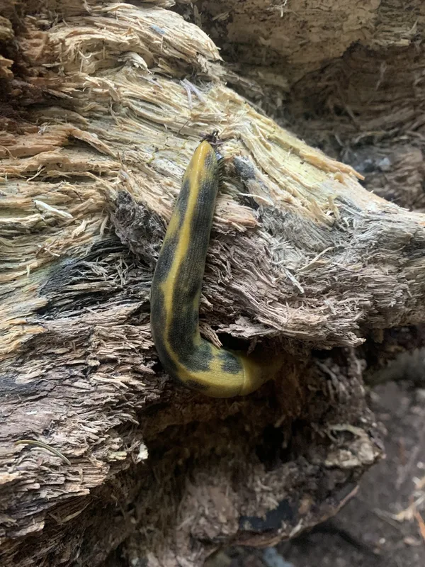
Button's Banana Slug Ariolimax buttoni -
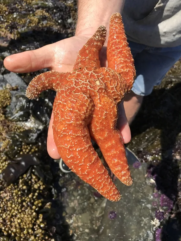
Ochre Sea Star Pisaster ochraceus -
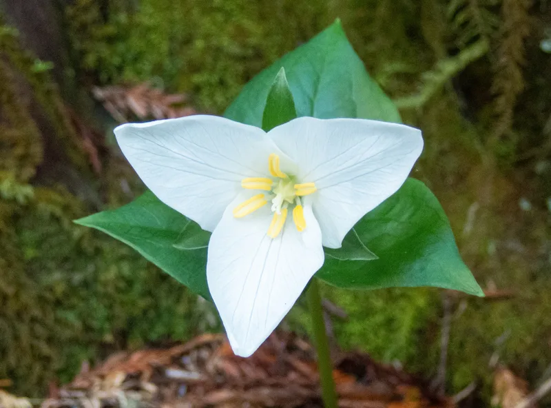
Pacific trillium Trillium ovatum -
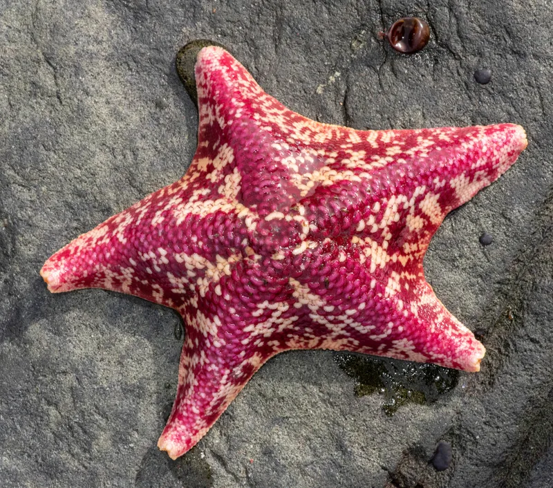
Bat Star Patiria miniata -
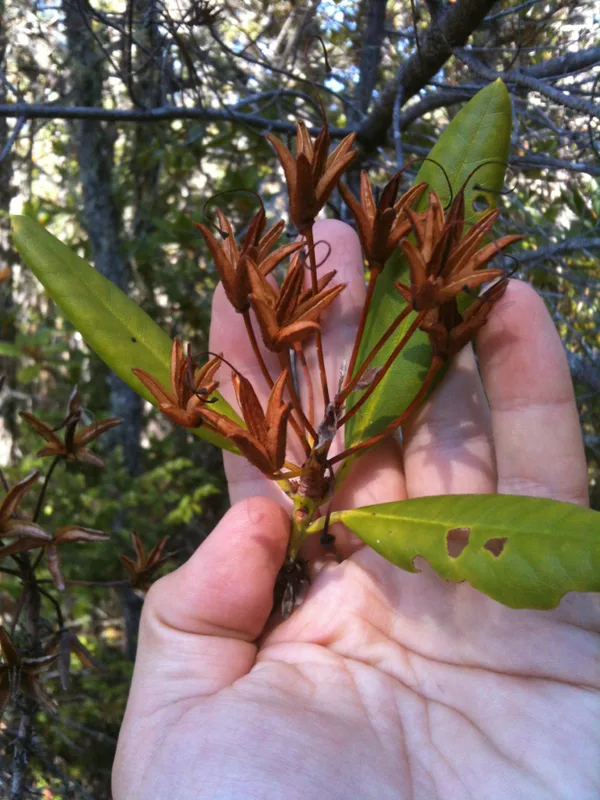
Pacific rhododendron Rhododendron macrophyllum -
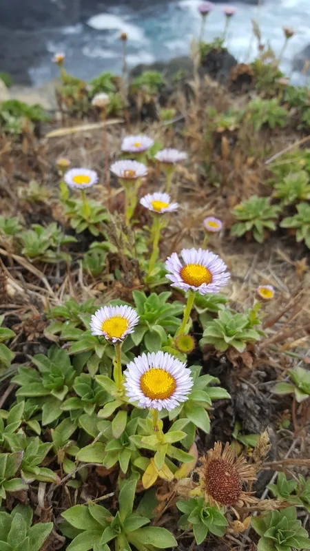
seaside daisy Erigeron glaucus -
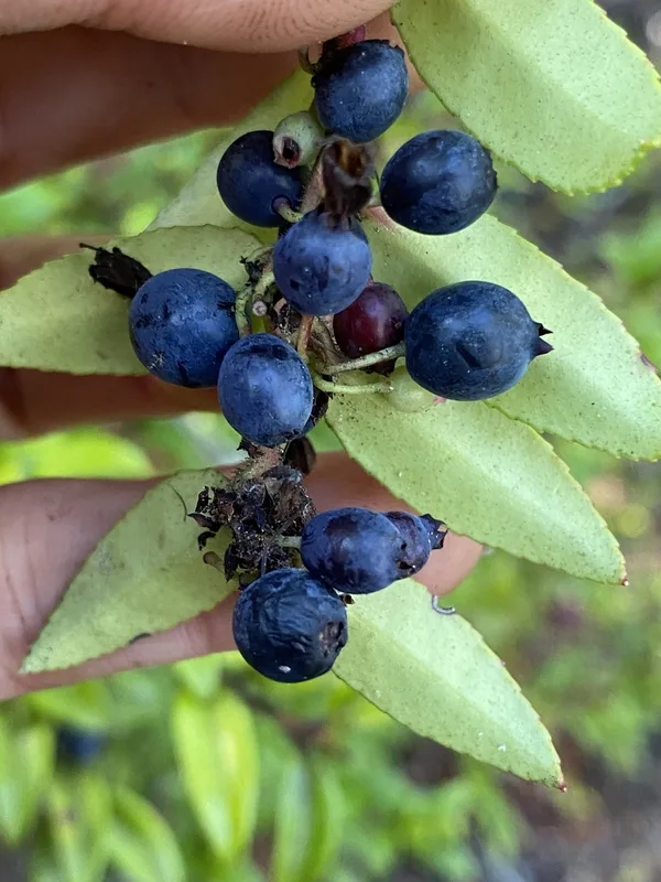
Evergreen Huckleberry Vaccinium ovatum -
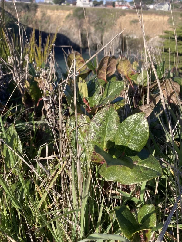
salal Gaultheria shallon -
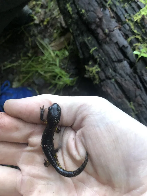
Ensatina Ensatina eschscholtzii -
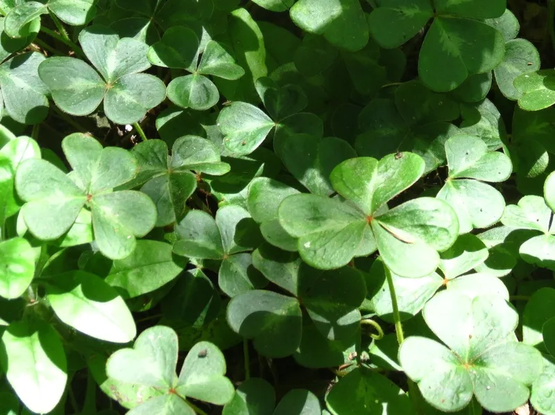
Redwood Sorrel Oxalis smalliana -
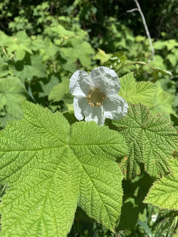
thimbleberry Rubus parviflorus -
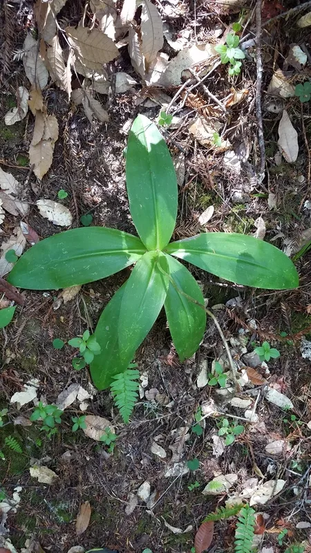
Andrews' Clintonia Clintonia andrewsiana
Field Notes · Fog Coast lens · Mendocino Headlands State Park · 39.2863, −123.7614