Grossglockner
Grossglockner · Carinthia, Austria
The rock here remembers where the ice pressed against it: sharpened to points, cut into blades, hollowed into basins it never quite grew back to fill.
Why here
From below, Grossglockner doesn’t read as a dome or a ridge — it reads as a blade, narrowed to a point where several faces meet at once. That shape isn’t an accident of upheaval; it’s what’s left after ice has spent a very long time working a mountain from more than one side. Grossglockner is Austria’s highest peak and the highest in the Alps east of the Brenner Pass, standing on the main ridge of the Central Eastern Alps, at the Alpine divide itself. On its eastern slope lies the Pasterze, Austria’s most extended glacier — proof the process that shaped this whole massif hasn’t finished. Around the summit, other named peaks carry the same signature: horns, sharp ridges, and place names that still use the old word for glacier, long after the ice that earned the name has thinned or pulled back. This note follows that one idea across the massif — how moving ice sculpts standing rock, and what it leaves for you to read once it’s gone, or almost gone.
The story
The bedrock under all of this is old and much travelled. What’s exposed around Grossglockner today is a metamorphic rock — schist and phyllite, with pockets of serpentinite, quartzite, and carbonate — laid down as sediment and ocean floor between the Jurassic and Cretaceous, then folded and cooked deep in the crust long before ice arrived to shape its surface. By the time glaciers set to work, they had an already-hardened, already-layered slab of rock to cut into, which is part of why the resulting shapes hold an edge so well.
Life above and around that ice is sparse but specific: marmots denning in the boulder fields, cushion plants like moss campion and purple saxifrage flowering low and tight against the wind, choughs and vultures riding the same up-drafts along cliffs that ice once undercut. None of it is lush, and none of it needs to be — this is a community built for cold, thin soil, and a short working season.
People came to the ice more than they came for it: mountaineers testing routes up the Glockner group’s ridges and faces, and later a public road built across the range’s high passes, giving anyone with a car a look at glaciated country that used to take real effort to see. The record here is mostly about access — who reached it, and how — rather than settlement; this was always a place people visited, not one they lived in.
The sites
The horn the ice built
Großglockner
47.0745, 12.6939
At just under 3,800 metres, Grossglockner is Austria’s highest mountain and the highest peak in the Alps east of the Brenner Pass — part of the Glockner Group within the Hohe Tauern range, standing directly on the main ridge of the Central Eastern Alps and on the Alpine divide itself. The Pasterze, Austria’s most extended glacier, lies on its eastern slope, a living reminder that the process that built this peak’s shape is still, however slowly, at work. Seen from a distance, Grossglockner doesn’t look like a dome or a rounded summit; it comes to a narrow point, with several distinct rock faces meeting close together near the top. That kind of shape is a signature of glacial erosion at high elevation: ice doesn’t grind a mountain down evenly, it eats inward from separate hollows on different sides, and where two or three of those hollows meet, the rock between them gets narrowed to a blade rather than worn to a rounded hill. Grossglockner is also a serious mountaineering objective, its upper routes crossing glaciated terrain that demands real experience with ice, rope work, and changing conditions — a summit to study as much as to stand on.
From a clear vantage below, trace the summit’s outline against the sky. Instead of one smooth curve, look for several distinct faces meeting near the top in sharp lines — each face marks where a separate patch of ice once carved its own hollow into the mountain, working inward until only the rock between them was left standing.
- AccessExpedition
- ExertionStrenuous
- TimeWorth two days
Kleinglockner
47.0742, 12.6947
Kleinglockner rises immediately beside the main summit, close enough that the two are usually spoken of together, joined by a narrow ridge of rock. That connecting ridge deserves as much attention as either summit: it’s an arête, the thin wall of rock left standing when ice carves into a mountain from two sides at once, hollowing out a basin on each face until almost nothing is left between them but a blade you can, in places, straddle with a foot on either side. Kleinglockner and its ridge sit within the same glaciated high country as Grossglockner, part of the Glockner Group on the Hohe Tauern’s main divide, and reaching it means crossing the same kind of terrain — snow, ice, and exposed rock — that shaped it in the first place. It’s a smaller, quieter companion peak, easy to overlook next to its taller neighbor, but it makes the mountain-building process legible in a way the main summit alone doesn’t: here the wall of rock that ice left standing is visible, rather than just its finished, pointed result.
Look at the ridge running between Kleinglockner and the main summit. Notice how thin it is compared to an ordinary hillside spine — a true edge rather than a slope — the mark of ice cutting a hollow into both sides of the same rock at once until almost nothing but the ridge itself remained.
- AccessExpedition
- ExertionStrenuous
- TimeHalf a day
Glocknerhorn
47.0767, 12.6916
Glocknerhorn carries its shape in its name. A “horn” in this kind of country is a peak sharpened by more than one glacier working inward from different sides — cirques of ice biting into a mountain’s flanks until the untouched rock between them wears down to a single pyramid point. Glocknerhorn stands within the same close cluster of summits as Grossglockner and Kleinglockner, part of the Glockner Group’s high, glaciated core along the Hohe Tauern’s main ridge, and its silhouette is one more version of the same lesson: ice doesn’t erode a mountain evenly, it erodes it from specific directions, and the shape left behind records exactly how many directions that was. From a distance, it’s worth comparing Glocknerhorn’s profile to its neighbors — some horns are sharper and more symmetrical than others, depending on how many separate ice hollows fed into their carving and how evenly those hollows were spaced around the peak. None of that requires climbing to appreciate; it’s visible, and readable, from any clear viewpoint across the valley.
Pick out Glocknerhorn’s outline and count how many distinct faces meet at its summit point. Each face likely once held its own small patch of ice, cutting inward on its own schedule — the more faces you can count, the more separate hollows worked together to leave this particular point standing.
- AccessExpedition
- ExertionStrenuous
- TimeHalf a day
Names the ice left on the map
Krumlkeeskopf
47.0814, 12.9141
The second half of Krumlkeeskopf’s name is telling: “Kees” is the regional word for glacier, and it survives in dozens of summit and valley names across this range long after some of the ice it once described has thinned or withdrawn. Krumlkeeskopf sits east of the Glockner massif’s highest peaks, in glaciated high country of its own, and its name is a small piece of local memory — a record, written into the map rather than into any document, of where ice once mattered enough that the people naming these mountains reached for that word instead of another. Standing near a peak like this, it’s worth remembering that names outlast the thing they were named for; a “kees” peak doesn’t guarantee ice today, only that ice mattered enough, at some point, for someone to reach for that word here. Ground newly free of ice tends to look different from ground exposed a long time — paler, less weathered, often bare of the lichen that takes years to establish — and that difference is one of the few visible clues to how far, and how recently, the ice here has moved.
Look at the rock and ground near Krumlkeeskopf for patches that are noticeably paler or barer than the rock around them. Older, long-exposed rock tends to be weathered and often carries lichen; pale, lichen-free rock is usually ground more recently uncovered — one of the few visible signs of where ice has been, and how recently it left.
- AccessHalf-day hike
- ExertionModerate
- TimeHalf a day
Schneehorn
47.0783, 12.9307
Schneehorn’s name translates plainly — “snow horn” — and like Krumlkeeskopf a valley or two over, it’s a small piece of vocabulary the map has kept even as conditions on the ground shift year to year. Horn peaks in glaciated country tend to hold snow and ice longest on their shaded, north-facing sides, where direct sun reaches least and cold air pools; that’s also generally where a cirque glacier gets its start, since snow that survives the summer builds into ice over years rather than melting away completely. Schneehorn stands within the same broad high country east of the Glockner Group’s main peaks, part of a landscape where naming and geography line up closely — mountains got called what they looked like, season after season, by people who spent enough time among them to notice the pattern. Watching how snow persists unevenly across a single peak, rather than as a uniform cap, is one of the more direct ways to see how a glacier chooses its starting point: not the highest ground necessarily, but the coldest, most sheltered ground.
Compare the snow cover on Schneehorn’s different faces. The shaded, north-facing slopes typically hold their patches longest into the year; that uneven, one-side-at-a-time melt pattern is close to how a glacier picks its starting spot — not simply the top of a mountain, but wherever cold and shadow let snow survive longest.
- AccessHalf-day hike
- ExertionModerate
- TimeHalf a day
Vantage points on a glaciated world
Tauernfenster
47.1083, 12.8344
Tauernfenster takes its name from a piece of geology worth knowing before looking out from it: a “window,” in this sense, is a spot where erosion has cut down through an overlying sheet of rock to expose different, often older or deeper, rock beneath it — the way a hole worn through a rug reveals the floor underneath. The bedrock exposed across much of this range is a metamorphic rock — schist and phyllite, with occasional bands of serpentinite, quartzite, and carbonate rock — laid down originally as sediment and ocean floor, then folded and recrystallized deep in the crust long before any glacier reached the surface to carve it. From this viewpoint, the rock underfoot and the rock in the surrounding peaks is a good place to notice that layered, sheet-like texture directly: it splits along flat planes rather than breaking randomly, a texture that comes from being squeezed and heated far below ground, not from anything ice has done since. Glacial carving works on whatever rock it’s given; here, it was given rock already patterned by an older, slower process.
At the viewpoint, look closely at a broken piece of the rock underfoot. If it splits into flat, sheet-like layers rather than an irregular chunk, that’s the schist and phyllite this range is built from — rock folded and flattened deep in the crust long before any glacier arrived to carve its outer shape.
- AccessShort walk
- ExertionEasy
- TimeAn hour
Racherin
47.0814, 12.7939
Racherin is a lower, quieter summit than its famous neighbor — a little over 3,000 metres, roughly six kilometres northwest of Heiligenblut, in the same Glockner Group of the Hohe Tauern range. Its normal route is unmarked and mostly without a trodden path; in dry, snow-free conditions it isn’t technically difficult, but it is laborious, and finding the way requires a good sense of direction rather than following any marked trail. What makes the effort worth noting for this lens is the view it delivers: in suitable weather, Racherin gives an especially good look back at Grossglockner and the surrounding mountain country — a chance to see the whole glaciated massif at once, ridgelines and separate faces included, rather than standing inside it the way you do on the mountain itself. A view like that is its own kind of instrument: from a neighboring, lower summit, the pattern that’s hard to read up close — which face fed which hollow, how the ridges divide one basin from the next — becomes visible all at once, the way a diagram makes sense of something a close-up photograph can’t.
From Racherin’s summit, find Grossglockner across the valley and follow the ridgelines running down from its peak with your eye. Each ridge marks where two separately carved rock faces meet — a pattern far easier to trace from here, at a distance, than it would be standing on the mountain itself.
- AccessExpedition
- ExertionStrenuous
- TimeHalf a day
When it's best
There’s no single month that owns this landscape. Even across the sampled days of later winter, highs here hover only a few degrees above freezing while nights stay well below it — a reminder that at this elevation winter’s grip is long and slow to loosen. By mid-summer the high routes and roadside viewpoints open up, alpine flowers come into bloom on the cushion plants, and birds like the yellow-billed chough and the white-winged snowfinch, a true snowline specialist, are easiest to find working the rock right at the edge of where snow still lingers. Shaded cirques and north-facing slopes hold their snow patches longest, often well past when open ground nearby has cleared, so the line between bare rock and ice is never fixed — it shifts depending on which face of the mountain you’re looking at.
Go deeper
The names behind what you saw - Bündner Schiefer (Schistes Lustrés) — the metamorphic schist and phyllite, with minor serpentinite, quartzite, and carbonate rock, that makes up much of this range’s bedrock, broadly dated Jurassic to Cretaceous. - Mesozoic sedimentary rocks — a broadly similarly aged unit associated with the same bedrock. - Kees — the regional word for glacier preserved in names like Krumlkeeskopf. - Tauernfenster (Tauern Window) — the geological term for a spot where erosion has cut through an overlying rock sheet to expose different rock beneath, echoed directly in that viewpoint’s name. - Marmota marmota (Alpine Marmot), Saxifraga oppositifolia (Purple Saxifrage), Silene acaulis (Moss Campion), Gentiana bavarica (Bavarian Gentian), Leontopodium nivale (Edelweiss) — signature alpine plants and animals of this ground. - Pyrrhocorax graculus (Yellow-billed Chough), Montifringilla nivalis (White-winged Snowfinch), Gyps fulvus (Eurasian Griffon), Gypaetus barbatus (Bearded Vulture) — birds recorded working this same high, rocky, glacier-edged terrain.
To read next - Wikipedia, “Grossglockner” — the peak’s basic vitals, including its place on the Alpine divide and the Pasterze on its eastern slope. - Wikipedia, “Racherin” — the only detailed, on-the-ground route account here, worth reading before attempting that summit. - Wikipedia, “Grossglockner High Alpine Road” — how a route across this glaciated high country became something the public, not just mountaineers, could cross. - Wikipedia, “Mountaineering” — background on how routes like the ones up Grossglockner and its neighbors are approached and described. - “The height of the Grossglockner” (Institute of Geology, West Germany, 1981) — a reminder that even a mountain’s exact height has been the subject of dedicated measurement.
The names behind what you saw
What lives here, and what it's called. Photographs from open collections — an aid to identification, not decoration.
-
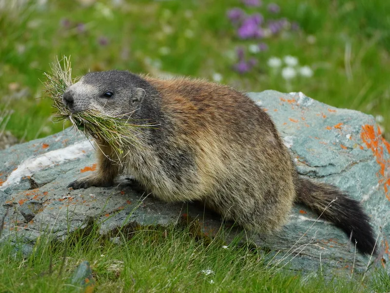
Alpine Marmot Marmota marmota -
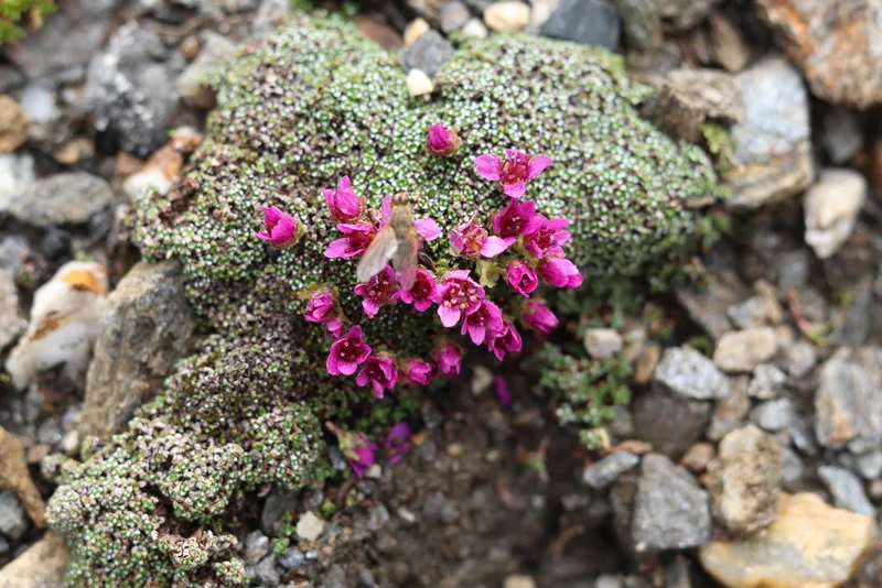
Purple Saxifrage Saxifraga oppositifolia -
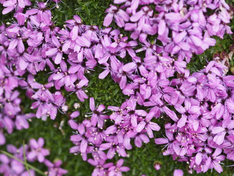
Moss Campion Silene acaulis -
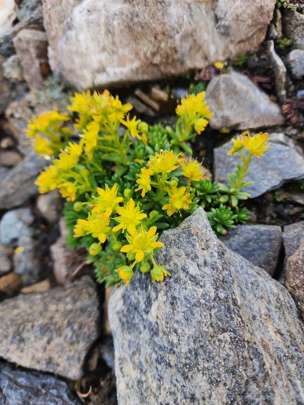
Yellow Saxifrage Saxifraga aizoides -
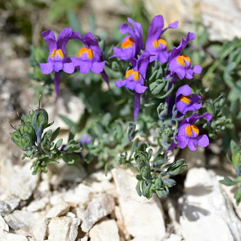
Alpine Toadflax Linaria alpina -
Eurasian Griffon Gyps fulvus -
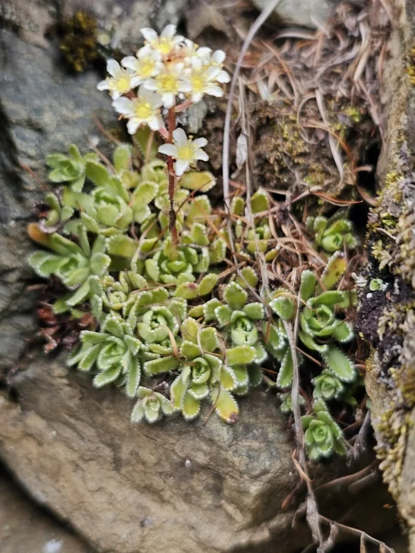
Livelong Saxifrage Saxifraga paniculata -
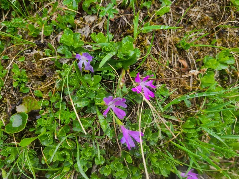
Fairy Primrose Primula minima -
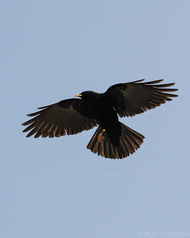
Yellow-billed Chough Pyrrhocorax graculus -
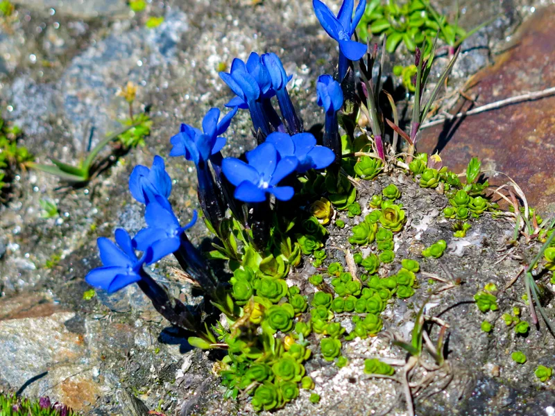
Bavarian gentian Gentiana bavarica -
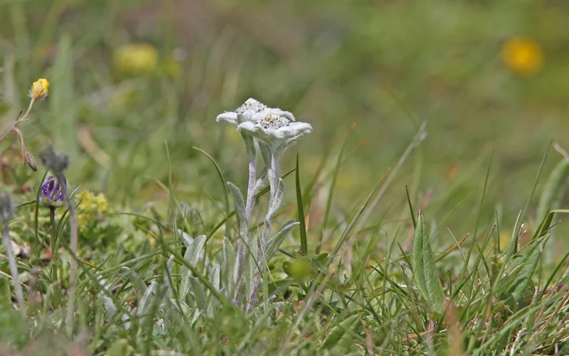
Edelweiss Leontopodium nivale -
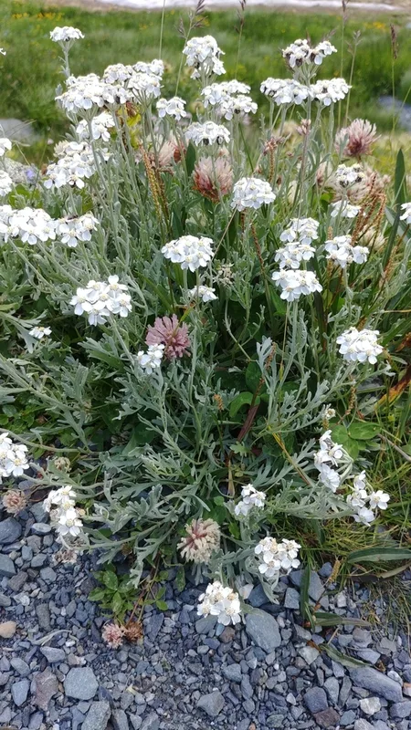
Silvery Yarrow Achillea clavennae
Field Notes · Ice & Glaciers lens · Grossglockner · 47.0385, 12.8408