Blyde River Canyon
Blyde River Canyon · Mpumalanga, South Africa
Every cliff in this reserve is rock that hasn't lost yet — and every gorge is rock that has.
Why here
Long before there was a canyon here, there was simply very old rock — layered stone laid down when the crust itself was still young, and left mostly alone for the better part of three billion years. Then came water: rivers with modest names, the Blyde and its smaller partners, cutting down through rock that had already stood still for an almost unthinkable stretch of time. That contrast is the whole story this reserve keeps telling from every angle — ancient, patient stone against a river too small to look dangerous, that nonetheless never stopped working. Stand at any viewpoint along the escarpment and you’re seeing the current state of an argument that has been running for longer than the rock has any memory of being whole, one the water is still, slowly, winning: domes and towers left standing where the rock resisted, sheer walls where it gave way clean, whole plateaus of high ground still waiting their turn. Nothing here happened quickly. Everything here is still happening. This note follows that same argument from the escarpment’s edge down to the water still doing the cutting.
The story
The land here is stacked deep and old: a basement of volcanic and plutonic rock pushing toward three billion years old, buried under the shales, quartzites and old lava of the Wolkberg Group, themselves capped by a slightly younger layer of Paleoproterozoic sediment and volcanic rock. All three units finished forming long before there were rivers here to speak of; the canyon is what the Blyde and its tributaries — among them the Treur, which meets the Blyde at Bourke’s Luck Potholes, a run of potholes carved into the rock — have managed to remove from that stack since.
Life took hold on what the erosion left standing. Sun-facing cliffs here are lizard country — Sekukhune flat lizards wedge into narrow rock cracks, while Southern Rock Agamas and Highveld Crag Lizards bask in the open on warm mornings. Real yellowwoods, an old and slow-growing tree family, root in sheltered ravines, while candelabra aloes and proteas hold the drier, more exposed slopes. Crag-nesting birds work the same rock faces the lizards do, for the same reason: cliffs offer ledges nothing can easily climb to.
People arrived and made the high ground count for something too. The Mapulana people, under Chief Maripe Mashile, held Mariepskop as a stronghold and, in December 1864, met and turned back an invading Swazi force nearby — a notable case of successful indigenous resistance against a dominant regional power of the era. Later arrivals came for gold, then for the view; a mining camp near the escarpment’s edge grew, eventually, into a town that lives mostly off the second.
The sites
Windows on the drop
Gods Window
−24.8764, 30.8891
Gods Window is where the escarpment simply quits holding its edge. Stand at the rail and the ground falls away in one motion, roughly seven hundred metres down to the lowveld stretched out below — bushveld and farmland fading blue into the distance most days, sometimes vanishing into cloud that pools against the cliff. This isn’t the river canyon itself, but it’s the same argument at a larger scale: high ground losing a fight it’s been losing for a very long time. The rock underfoot belongs to the same old package that the Blyde and its tributaries have spent ages cutting through elsewhere in the reserve — layered shale, quartzite and old lava laid down when the rock itself was still young. From here you’re not looking at a canyon so much as standing on what a canyon leaves behind: the shoulder of high country the river hasn’t reached yet, at least not here. On a clear day the view reaches far into the lowveld; on a misty one, the window earns its name by closing.
From the rail, look at how abruptly the vegetation changes right at the drop-off — cool-climate plants giving way to a warmer, denser green far below. That line marks where the escarpment’s climate ends and the lowveld’s begins, not a gradual blend but a hard edge, the same way the rock itself changes abruptly wherever the river has cut through it elsewhere in the canyon.
- AccessDrive-up
- ExertionEasy
- TimeAn hour
Devil's Window
−24.6725, 30.9141
Just along the escarpment from its more famous neighbor, Devil’s Window looks out over the same great drop from the same layered old rock — the shale and quartzite package that makes up most of the reserve’s high ground, exposed everywhere the escarpment has crumbled or the rivers have cut down. Where Gods Window draws the crowds, this one tends to sit quieter, though the geology underfoot doesn’t know the difference. Both viewpoints mark the same boundary: the edge where the Drakensberg escarpment gives way to the lowveld, a line the rivers below have been working at for longer than the rock has any memory of being whole. Come here less for a different view than for room to actually look at it — to work out for yourself where the escarpment’s edge sits relative to the river gorges cutting back into the high ground elsewhere in the reserve, and to notice that a canyon and an escarpment are really the same story, told at two different distances.
Look along the line of the escarpment in both directions from where you stand. Where it stays a fairly straight wall, the rock has resisted; where you can see it notch inward, a river or stream is working its way back into the high ground from below — the beginning of a canyon, seen from the top.
- AccessShort walk
- ExertionEasy
- TimeAn hour
Wonderview
−24.8686, 30.8967
Wonderview does what its name promises without needing to say much else: a clean look out over the Blyde River’s country from the escarpment edge, its rivers threading through the valleys below in the general direction of the lowveld. The rock at your feet is part of the same old, layered package — shale, quartzite, basalt — that shows up wherever the canyon has cut deep enough to expose it, meaning this ordinary-looking viewpoint stands on the same material the river has spent a very long time working through elsewhere. There’s a temptation at viewpoints like this to look for one dramatic feature and move on; resist it. The reward here is in the layering itself — pale bands of harder rock and darker bands of softer rock, visible if you trace the cliff faces below with your eye, each one a chapter in the same long argument between water and stone that carved the canyon proper a short distance away.
Trace one of the cliff faces below you with your eye, from top to bottom. Look for changes in color or texture running roughly horizontal — bands of harder and softer rock stacked on each other. The ledges and steps in the cliff mark where a softer band wore back faster than the rock above and below it.
- AccessDrive-up
- ExertionEasy
- TimeAn hour
The rondavels, and the long bend
Three Rondavels Viewpoint
−24.5737, 30.7989
The view here is of three rounded rock towers standing apart from the canyon wall behind them, each capped and domed rather than sharp — rondavel is the Afrikaans word for the round, thatched huts these towers are named for, and once you’ve heard it the resemblance is hard to unsee. They stand here because they’re made of tougher rock than what used to surround them; the softer material wore away first, leaving the domes standing free while the land around them dropped. Look past the three best-known towers and you’ll find they’re not alone — several more named summits rise from the same cluster, all shaped by the same uneven contest between rock and erosion. The river responsible sits below and out of sight from here, but its work is written into everything visible: this whole amphitheater is what’s left after a very long, very patient removal of everything the river and its side-streams could carry away. What didn’t wash away is what you’re looking at.
Compare the shape of the three domed towers to the cliff wall behind them. The towers are rounded on every side; the wall behind is a flat, continuous face. That difference in shape is the difference between rock that stood alone against erosion from every direction, and rock that still has neighbors holding it up.
- AccessDrive-up
- ExertionEasy
- TimeAn hour
World's End Viewpoint
−24.5693, 30.7850
World’s End Viewpoint looks out along the same stretch of canyon as its Rondavel-facing neighbors, but from a point where the gorge bends and the drop feels less like an edge and more like a room opening out. The name fits the feeling more than any geological fact: from here the canyon reads as a single large space rather than a series of separate cliffs, the different viewpoints along this stretch really just different windows onto one continuous piece of river-cut country. The escarpment wall on the far side shows the same old layered rock visible everywhere else in the reserve, tilted and stacked in bands that predate almost everything else about this landscape. Spend time comparing this angle to the more famous nearby viewpoints; the canyon looks different from every one of them, and none of those views is more true than the others — they’re just different cross-sections of the same long cut.
Pick a single point on the far wall of the canyon and watch how its position relative to you seems to shift as you walk a short distance along the viewpoint’s edge. The parallax is a rough way to feel the actual scale of the gap the river opened — closer features shift more than distant ones.
- AccessShort walk
- ExertionEasy
- TimeAn hour
Lower Viewpoint
−24.5736, 30.7841
As the name plainly says, this viewpoint sits lower than most of the others along this stretch of rim, which changes the angle more than it changes the view. From here you’re closer to eye level with the mid-height cliffs and rock towers that, from the higher viewpoints nearby, you mostly look down onto — a useful correction, since looking down at a canyon can flatten it, make the drop read as a picture rather than a piece of ground with real depth. Take the different elevation as an invitation to notice scale: features that looked modest from above often turn out to be sheer, tall cliffs in their own right once you’re looking at them more nearly straight on. The rock itself is unchanged from the higher stops nearby, still the same old, layered package the whole reserve sits on top of — shale, quartzite, basalt, laid down long before there was a river here to cut into any of it. What changes, stop to stop, is only the geometry of how you’re allowed to see the same old argument play out.
Find a rock face or tower that you also saw from a higher viewpoint nearby, and look at it again from here. Note how much taller or steeper it appears at this lower angle — a reminder that height is often underestimated when a cliff is viewed from directly above.
- AccessShort walk
- ExertionModerate
- TimeAn hour
Where water still works
Berlin Falls
−24.8446, 30.8420
Berlin Falls is one of the more direct places in the reserve to watch a river actually do the work this whole landscape is built from: water dropping over a ledge of harder rock, cutting back into the softer layers below it a little at a time. The fall is narrow rather than wide, more a long white ribbon than a broad curtain, threading down a cliff face cut into the same old layered rock — shale, quartzite, basalt — that makes up most of the reserve’s high ground. Falls like this one mark a place where the river hasn’t yet finished evening out its path; upstream of the ledge the water is still working at a gentler grade, and it’s only at the lip that the harder rock forces a sudden drop. Given enough time, the same process that carved the canyon downstream will eventually wear this ledge back too, and the falls will retreat upriver, a little at a time, the way waterfalls generally do.
Watch where the water actually leaves the rock at the top of the falls, rather than the falls as a whole. That exact lip is the hardest, most resistant point on this stretch of river — everything downstream of it has already worn away faster than the rock at the lip has.
- AccessDrive-up
- ExertionEasy
- TimeAn hour
Mariepskop
−24.5390, 30.8714
Mariepskop is the highest ground in the whole Blyde River Canyon system, its summit standing well over the rim of the canyon it borders, faced on several sides by sheer cliff. The mountain takes its name from Maripe Mashile, a nineteenth-century Pulana chief whose people used its heights as a stronghold — high, cliff-guarded ground has always been useful for the same reason the canyon is dramatic: it’s hard to get to, and harder still to take. In the twentieth century the mountain took on a different kind of high-ground use, when roads and infrastructure went in to service a military radar station on the summit. The mountain is built of old, layered sedimentary rock from the same broad rock family exposed throughout the canyon below, which means the summit and the river gorge are, geologically, close relatives — one is simply the part of that old rock package that has so far refused to come down. Two neighboring peaks flank it on either side, part of the same resistant high country the rivers around here have not yet finished working through.
From the summit, look for the sheer rock faces on the flanks below you rather than the view outward. Cliffs this steep usually mean the rock is holding together well under its own weight — a rough, at-a-glance way to tell resistant rock from the kind that slumps into softer slopes.
- AccessHalf-day hike
- ExertionStrenuous
- TimeHalf a day
When it's best
The escarpment sits high enough that its weather runs distinctly cooler than the lowveld stretched out below it, so it’s worth planning for two climates in the same day. Like most of this part of South Africa, the rain here mostly falls in summer, which means the cooler, drier months tend to bring the clearest, longest views from the rim — though mist can still close in on the escarpment edge without much warning at any time of year. Reptiles like the flat lizards and rock agamas that work these cliffs are most reliably out and basking on a sunny morning, whatever the month. There’s no clearly wrong season to visit; the rock has been arguing with the river for far longer than any one season could matter, and the view keeps making the same point no matter what’s blooming or moving below it.
Go deeper
The names behind what you saw
The oldest rock underfoot is a basement of volcanic-sedimentary and plutonic rock from the Neoarchean, roughly 2.8 to 2.5 billion years old. Above it sits the Wolkberg Group of the Transvaal Supergroup — shale, quartzite, arkose, subgreywacke, conglomerate, basalt and pyroclastic rock, laid down across the Mesoarchean to Neoarchean, about 3.2 to 2.5 billion years ago — the package most of the reserve’s viewpoints and cliffs expose. A younger cap of Paleoproterozoic sedimentary and volcanic rock, from the Siderian, sits above that, roughly 2.5 to 2.3 billion years old.
Species named in this note: Sekukhune flat lizard (Platysaurus orientalis), Southern Rock Agama (Agama atra), Highveld Crag Lizard (Pseudocordylus melanotus), real yellowwood (Podocarpus latifolius), Candelabra Aloe (Aloe arborescens), Common Protea (Protea afra).
To read next
- Blyde River Canyon Nature Reserve (Wikipedia) — the reserve’s official boundaries and its named formations, including Bourke’s Luck Potholes and the Devil’s and God’s Windows.
- Mariepskop (Wikipedia) — the mountain’s elevation, geology, and its twentieth-century radar-station history.
- Battle of Moholoholo (Wikipedia) — the 1864 conflict fought under Chief Maripe Mashile, for the human history behind the summit’s name.
- Panorama Route (Wikipedia) — the road connecting the canyon’s viewpoints and waterfalls, useful for working out which stops sit near each other.
- Graskop (Wikipedia) — the gold-mining camp turned tourism town at the canyon’s edge, and the origin of Gods Window’s name.
The names behind what you saw
What lives here, and what it's called. Photographs from open collections — an aid to identification, not decoration.
-
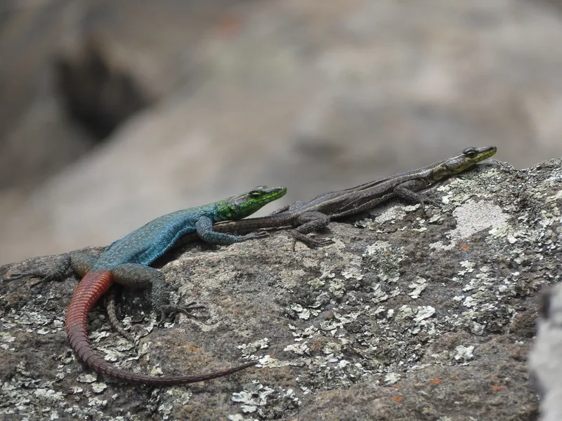
Sekukhune flat lizard Platysaurus orientalis -
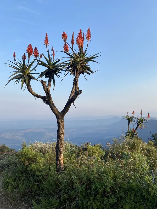
Candelabra Aloe Aloe arborescens -
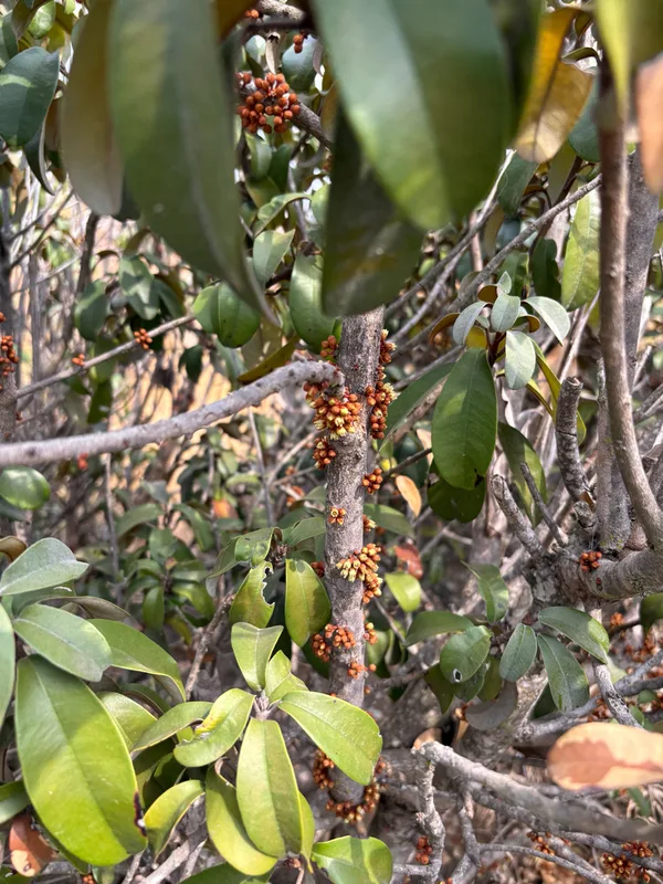
Stamvrug Englerophytum magalismontanum -
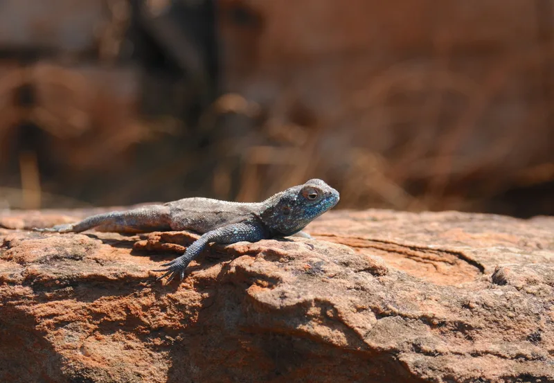
Southern Rock Agama Agama atra -
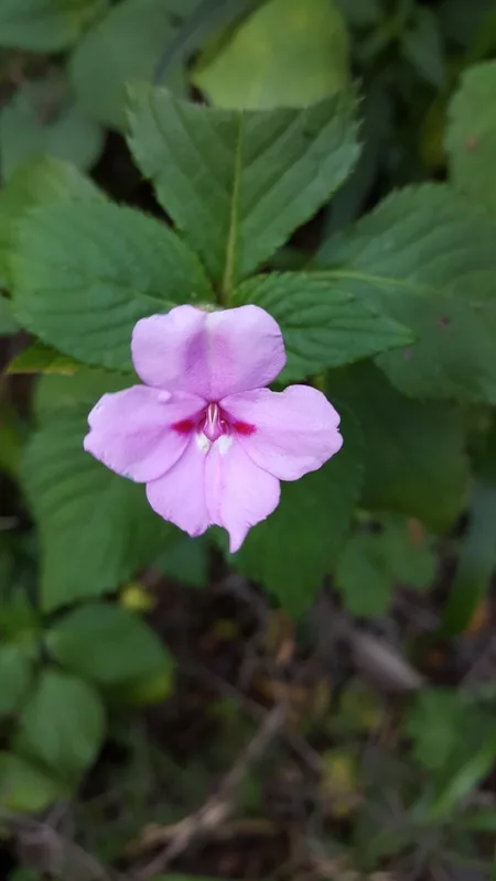
Transvaal balsam Impatiens sylvicola -
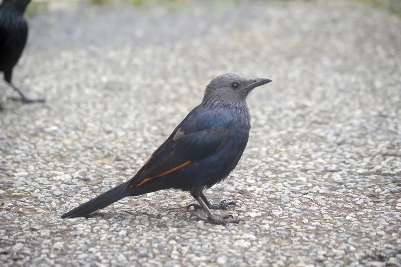
Red-winged Starling Onychognathus morio -
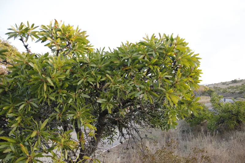
Common Protea Protea afra -
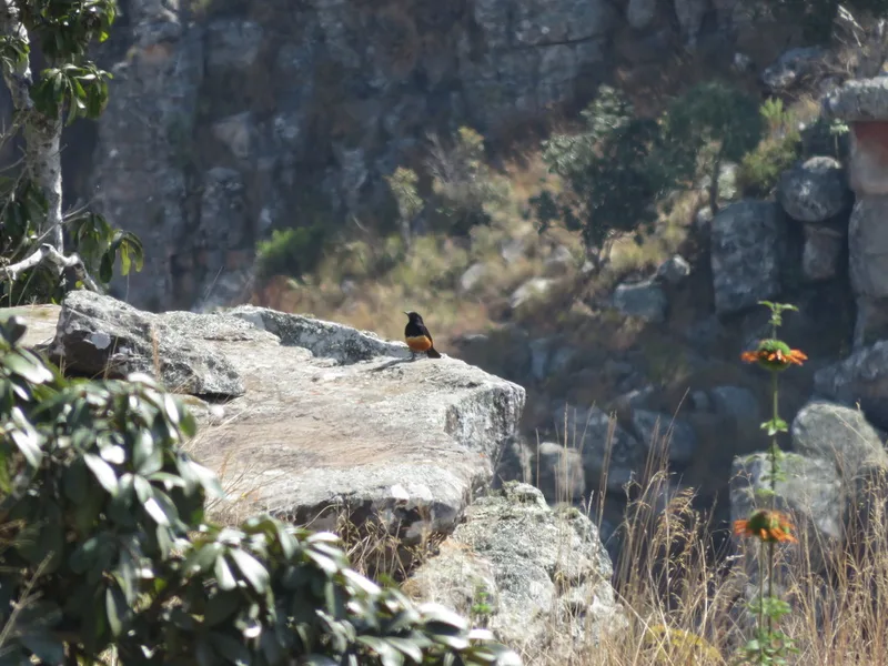
Mocking Cliff-Chat Thamnolaea cinnamomeiventris -
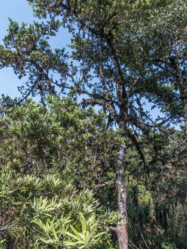
real yellowwood Podocarpus latifolius -
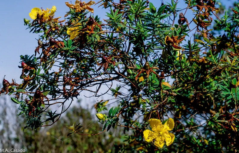
Common curry bush Hypericum revolutum -
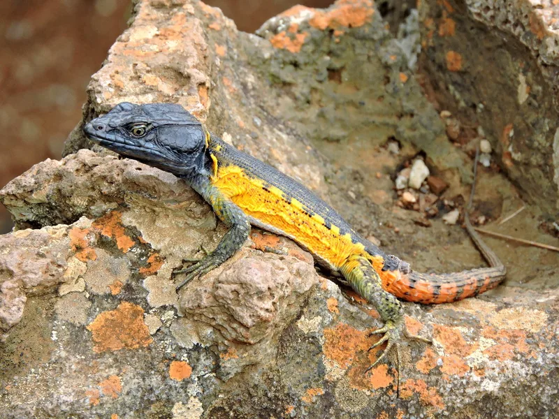
Highveld Crag Lizard Pseudocordylus melanotus -
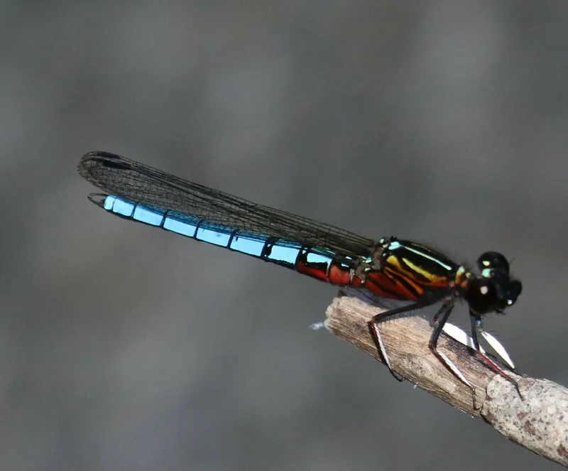
Dancing Jewel Platycypha caligata
Field Notes · Rivers & Canyons lens · Blyde River Canyon · −24.6789, 30.8843