The Big Island
Hawaiʻi Volcanoes National Park · Hawaii, USA
The ground here is still deciding what it will be.
Why here
Stand on almost any black rock in this park and you are standing on ground younger than the oldest person you know. This is one of the few places on Earth where you can watch land being made. Two volcanoes rise here — Kīlauea, among the most active anywhere, and Mauna Loa, the largest shield volcano on the planet — and both are still adding to the island. The rock underfoot is fresh lava, some of it laid down within a human lifetime, still so raw that in places nothing grows on it yet. Everything else follows from this one fact. The craters, the steam, the sudden bare fields of black glass, the single red-flowered tree pioneering a crack in the stone — all of it is the same story at different stages: the ground being poured, cooling, cracking, and slowly, patiently, being taken back by life. Spend a few days here and the landscape stops being scenery. It becomes a process you happen to be standing inside, still running.
The story
The island is the largest of its chain and the southeasternmost, and its heart is younger still — built flow by flow from the two volcanoes at its center. The commonest rock here came out of the ground in the last few thousand years, and it comes in two forms you learn to read by foot: smooth, ropy sheets that harden like poured batter, and jagged rubble sharp enough to shred a boot. Both are the same lava; only the speed of cooling tells them apart.
Onto this bare rock comes one tree first. The ʻōhiʻa lehua takes root in cracks where nothing else will, its red blossoms among the earliest signs that a lava field is becoming a forest. Where the ʻōhiʻa blooms, the ʻapapane follows — a small crimson bird that drinks from those flowers, most easily heard and seen in the cool months of early spring. Behind them come the low ferns and the ʻōhelo, its berries red against the black.
The Kanaka Maoli, the island’s first people, read this same ground as sacred. To them the volcano is presence, not disaster, and its eruptions are holy events. That older understanding is written into the land literally: near the summit, footprints pressed into wet ash during an explosive eruption in 1790 still mark where people crossed this ground more than two centuries ago.
The sites
The living summit
Uekahuna
19.4194, −155.2890
From this high point on the rim, the whole summit caldera of Kīlauea opens below you — a sunken plain more than two miles across, with the deeper pit of Halemaʻumaʻu notched into its far side. This is the most restless ground in the park: its floor has risen, drained, and collapsed within living memory, and it is the newest, most-worked surface of the entire mountain.
Look across to Halemaʻumaʻu, the deep pit set into the caldera floor. Watch for thin ribbons of steam rising from the ground where rainwater seeps down to hot rock and returns as vapor — the plainest daily sign that the mountain below you is still warm. On a still morning the plumes stand almost straight up.
- AccessDrive-up
- ExertionEasy
- TimeAn hour
Waldron Ledge
19.4228, −155.2569
A short walk from the road brings you to this ledge on the caldera’s eastern rim, looking back across the whole basin toward the far wall. The edge here is broken and stepped, the rim rock split along open cracks — the caldera slowly widening as its own edges give way.
Look down at the rim rock just below the railing and find the open cracks running parallel to the cliff edge. These are the caldera pulling itself apart at the seams, a little more with each big tremor. Then look at how far the opposite wall stands back — the basin you see was once smaller than it is now.
- AccessShort walk
- ExertionEasy
- TimeAn hour
A lava lake, cooled
Kilauea Iki
19.4157, −155.2427
In the closing weeks of 1959, this crater held a lake of molten rock. A fountain of lava rose from its floor to a height that set a record for the islands, and the pooled lava filled the pit like a cauldron. Today the floor is a flat grey crust, hardened over a body of rock that took decades to cool through — and a trail crosses straight over it.
From the overlook, trace the flat floor of the crater and find the low, humped area near one end — the vent the 1959 fountain rose from. Look for pale steam still threading up through cracks in the crust: more than sixty years on, the rock beneath is not yet fully cold.
- AccessShort walk
- ExertionEasy
- TimeAn hour
Puʻu Puaʻi Overlook
19.4120, −155.2506
The 1959 fountain did not only fill the crater next door; it also built this hill. Wind carried the spray of molten rock to one side, where it fell and piled into a steep cone of frothy cinder — a small mountain assembled in a matter of weeks. Nothing else in the park shows so plainly how fast this land can be built.
Look at the cone across from the overlook and notice how one side is far steeper and higher than the other. That lopsidedness is a record of the wind on the days it formed: the fountain sprayed molten rock, the wind carried it one way, and the cone grew tallest downwind. Face the steep side, and you are facing the way the wind blew in 1959.
- AccessDrive-up
- ExertionEasy
- TimeAn hour
Down the rift
Puʻu Huluhulu Outlook
19.3712, −155.2052
This older hill stands in the middle of much younger lava. When flows poured down from the vent nearby, they parted around its base and left it untouched — an island of older ground, still carrying trees, marooned in a sea of raw black rock. From the outlook you can read the line where the flow divided.
From the outlook, look at the boundary where the pale, plant-covered slope of the old hill meets the bare black lava around it. That sharp line is where a flow split and passed on either side. Follow the black rock with your eye, and you can often make out the direction it was moving, frozen mid-flow.
- AccessShort walk
- ExertionEasy
- TimeAn hour
Mauna Ulu
19.3673, −155.2016
Mauna Ulu is a volcano built in plain sight during a long eruption in the recent past — not a tall peak but a low, broad shield of piled lava, the shape all these volcanoes take. Flows from its vent ran for miles down the slope. Standing on its flank, you are on a mountain younger than many of the trees on the older ground nearby.
Walk out onto the lava around the vent and look closely at its surface. Where it is smooth and folded like coiled rope, it cooled from a fast, fluid flow; a few steps away, where the same lava turns to sharp rubble, it was moving stiffer and cooler as it stopped. The two textures, side by side, are the same rock caught at different speeds.
- AccessHalf-day hike
- ExertionModerate
- TimeHalf a day
Pauahi Crater
19.3716, −155.2253
Pauahi is one of a string of pit craters set along the road that follows the volcano’s east rift — a chain that also includes Hiʻiaka, Puʻu Huluhulu, Kānenuiohamo, Makaopuhi, and Nāpau. It is a clean, deep pit, longer than it is wide and hundreds of feet down: not built up by lava but collapsed, where the ground dropped into an emptied space below.
From the railing, look at the walls of the pit rather than its floor. Read the horizontal bands in the rock face — each is a separate old lava flow, stacked one on the next, that the collapse cut through and exposed like the layers of a sliced cake. Count how many you can pick out.
- AccessDrive-up
- ExertionEasy
- TimeAn hour
Kealakomo
19.3166, −155.1619
Kealakomo sits on a bench high on the flank of the volcano, where the land falls away in a long, bare slope toward the ocean. From here the scale of it is plain: mile after mile of black flows, some smooth and some broken, poured down this face and left with barely a plant on them.
Look out over the slope below and pick out the different shades of black and grey in the lava fields. The paler, greyer patches are older flows, slowly weathering and gathering the first dusty soil; the darkest, glassiest ones are younger, still nearly bare. You are looking at the same ground at several ages at once.
- AccessDrive-up
- ExertionEasy
- TimeAn hour
Where lava meets sea
Kau Desert Trailhead
19.3689, −155.3675
On the dry, downwind side of the summit lies a stretch of near-empty ground — dried lava, volcanic ash, sand, and gravel, with almost nothing growing on it. Rain here falls through the volcano’s fumes and reaches the earth slightly acid, which helps keep the desert bare. This trail leads out across the same ground where footprints pressed into wet ash during an explosive eruption in 1790 still survive.
Walk a little way out onto the ash and look down at the surface. Where the pale ash has hardened, watch for its texture — ripples, thin layers, and here and there the preserved shapes of old footfalls set into it. This is powdered rock, blown from an explosive eruption and set like plaster. Tread lightly and stay to marked ground.
- AccessHalf-day hike
- ExertionModerate
- TimeHalf a day
Hōlei Sea Arch
19.2948, −155.0976
At the very end of the road, the land stops in a low cliff of stacked lava flows dropping straight into the surf. The sea has carved an arch through one shoulder of that cliff — a plain sign that as fast as the volcano builds this coast outward, the ocean is already at work tearing it back down.
Stand at the overlook and watch the waves strike the base of the lava cliff below the arch. Notice how the rock is layered in flat bands — each an old flow — and how the surf works fastest at the softer seams between them. The arch is simply a seam the sea broke all the way through; given time, its span will fall.
- AccessDrive-up
- ExertionEasy
- TimeAn hour
When it's best
The park makes its own weather — cool and often wet at the summit, dry and stark down in the leeward desert, sometimes all in one afternoon. The cooler, wetter months of late winter and early spring are the liveliest for the forest birds: this is when the ʻapapane are busiest around the blooming ʻōhiʻa, their song easiest to catch in the morning before the trade winds pick up. The ʻōhiʻa itself carries some red flower in most seasons, heaviest in these cooler months. Whatever the month, mornings are clearer than afternoons, when cloud tends to build over the summit and rain moves in from the windward side. Volcanic activity keeps its own calendar and answers to no season — check current conditions before you go, because what is open and what is glowing can change from week to week.
Go deeper
The young rock underfoot is the Puna Basalt — pāhoehoe (the smooth, ropy lava) and ʻaʻā (the rough, broken kind), both tholeiitic basalt laid down within the last several thousand years; the deeper island is built of older shield-volcano rock. The pioneer tree is ʻōhiʻa lehua, Metrosideros polymorpha; the crimson bird that feeds on it is the ʻapapane, Himatione sanguinea. The red trailside berry is ʻōhelo, Vaccinium reticulatum; the tall tree ferns of the wetter craters are hāpuʻu, Cibotium glaucum; the grey ground-shrub of the bare fields is pūkiawe, Leptecophylla tameiameiae; and the sheets of low fern reclaiming lava are false staghorn, Dicranopteris linearis. The ground-nesting goose you may meet is the nēnē, Branta sandvicensis, the Hawaiian goose.
To read further: Harold Stearns, Geology and Water Resources of the Kaʻū District (1930), still the classic survey of this volcanic country; the U.S. Geological Survey’s geologic map of Kīlauea’s middle east rift zone (2006), for how the rift that feeds these craters is put together; the study of Mauna Loa’s submarine radial vents (2004), for the hidden, underwater half of the largest shield volcano; and Edward Wolfe’s geology of Mauna Kea (1997), for the older, quieter volcano to the north.
The names behind what you saw
What lives here, and what it's called. Photographs from open collections — an aid to identification, not decoration.
-
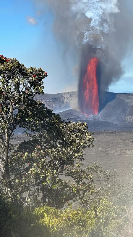
ʻŌhiʻa Lehua Metrosideros polymorpha -
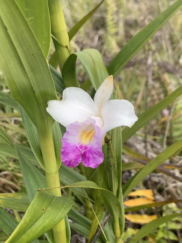
Bamboo Orchid Arundina graminifolia -
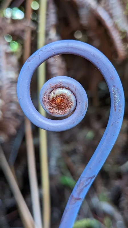
false staghorn fern Dicranopteris linearis -
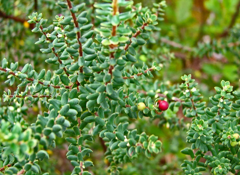
Pūkiawe Leptecophylla tameiameiae -
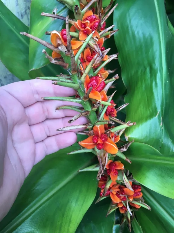
Kahili ginger Hedychium gardnerianum -
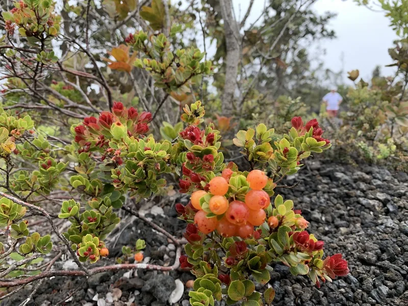
'ohelo 'ai Vaccinium reticulatum -
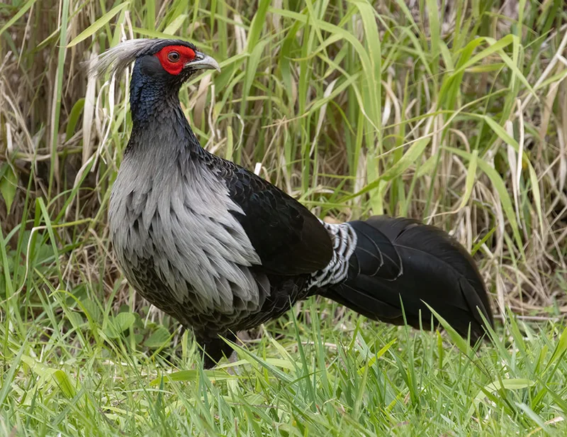
Kalij Pheasant Lophura leucomelanos -
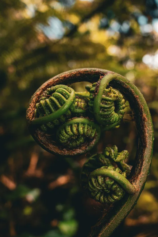
hāpu‘u pulu Cibotium glaucum -
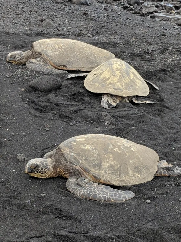
Green Sea Turtle Chelonia mydas -
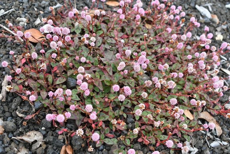
pink knotweed Persicaria capitata -
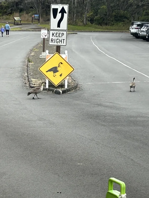
Hawaiian Goose Branta sandvicensis -
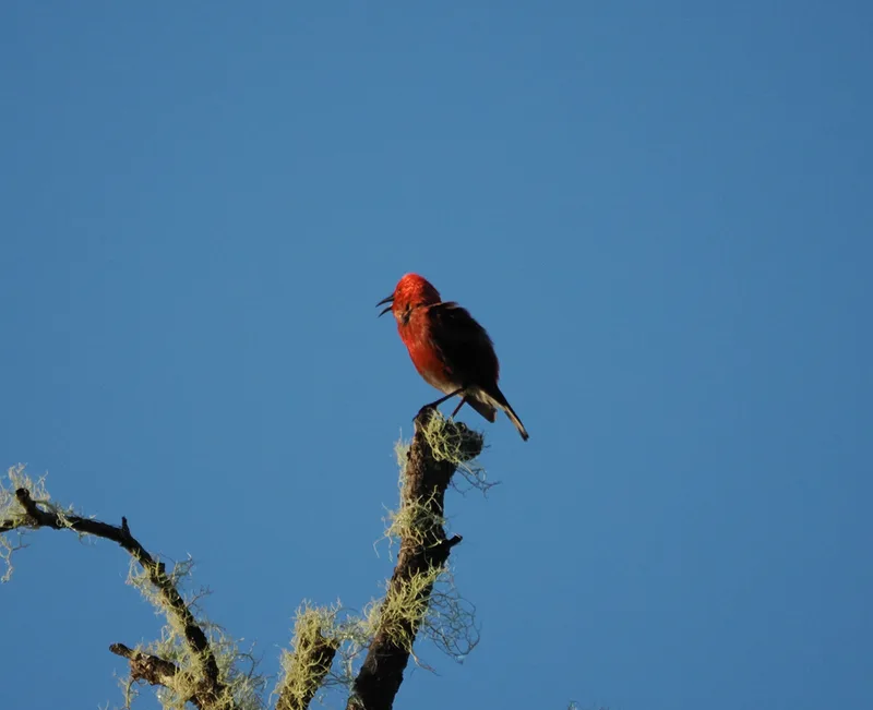
ʻApapane Himatione sanguinea
Field Notes · Volcanic lens · Hawaiʻi Volcanoes National Park · 19.2608, −155.3579