Arenal Volcano
Arenal Volcano · Alajuela, Costa Rica
Most of this ground has waited millions of years to cool. Arenal has not waited at all.
Why here
Stand at any of the viewpoints ringing Arenal and the mountain stops behaving like scenery. Most of the peaks visible from here belong to a landscape that has been building itself, slowly and violently, for tens of millions of years — this stretch of Costa Rica sits above an active subduction zone, part of a chain of volcanoes strung along the Pacific side of Central America. Arenal is the newest thing in that old family. Geologists judge it to be under 7,500 years old, barely a moment against the worn, rounded, deeply forested older volcanoes nearby, including its own quiet neighbor, Chato. That contrast — one cone still sharp-edged and active, the rest gentled by time — is the whole story here, and you don’t need training to read it. A lava flow with almost no soil sits beside forest with old, tall trees. A steep, bare-shouldered cone rises beside a slope so worn it has nearly forgotten it was ever a volcano. This note keeps returning to that single comparison, because it’s the one thing every viewpoint here, near or far, ends up showing.
The story
The land here is new by geological standards and ancient by any other. Central America’s Pacific edge sits above a subduction zone, the Cocos plate sliding beneath the Caribbean, North American, and Panama plates, and this particular stretch of coast has been raising volcanoes above that collision since long before humans existed to name them — the region’s volcanic record reaches back to the Permian. Arenal is simply the youngest working part of that very old machine, judged to be under 7,500 years old, built by a single vent into the clean cone visible from every viewpoint around it. Older rock crops up nearby too, deep-time volcanic material tens of millions of years old, a reminder that this ground has done this before, many times, long before Arenal existed.
Life moved onto the slopes as fast as the ground allowed it to. Coatis and eyelash vipers, curassows and hummingbirds, red-eyed tree frogs and strawberry poison dart frogs now share the mountain with lava flows still too young to carry much more than moss, sorting themselves onto whichever patch of forest, at whatever age, suits them.
The record is quieter on people. What survives are names — Arenal has been called Pan de Azúcar, Canaste, Volcán Costa Rica, Volcán Río Frío, and Guatusos Peak at different times, by different eyes looking at the same shape. Why each name stuck, and to whom, isn’t preserved. What’s preserved is the plainer fact: this cone has been worth naming, more than once, for as long as people have stood where you’re standing.
The sites
The cone, watched
Mirador de Volcán Arenal
10.4386, −84.7297
This viewpoint sets you directly across from Arenal’s cone, close enough that the near-perfect symmetry stops being a postcard idea and starts being a fact you can check with your own eyes. The mountain rises to roughly a mile above the surrounding lowlands, built from a single vent that has kept working long enough to stack itself into that classic triangle — steep sides, a small crater cut into the summit, no ridge or shoulder breaking the line. Most volcanoes this shape belong to a family: a young cone growing inside or beside an older, worn-down one, the record of one vent falling quiet and another taking over nearby. From here that whole idea is visible without any specialist knowledge, just distance and a clear line of sight. Come with patience rather than an itinerary — cloud tends to sit on the upper flanks for stretches of any day, and the summit’s full outline is a matter of waiting it out rather than timing it. The forest below the viewpoint climbs the lower slopes in the ragged, uneven way vegetation always does on ground with an active neighbor, thinner and younger the higher it goes.
Trace the skyline of the cone with your eye from base to summit. Note where the tree line gives out — that boundary marks roughly how far up the slope vegetation has had time to take hold since the ground last moved, and it will not sit at the same height on every side of the mountain.
- AccessDrive-up
- ExertionEasy
- TimeAn hour
Mirador Colada
10.4502, −84.7246
The name of this overlook is the plainest clue on the mountain: colada is the Spanish word for a lava flow, a river of melted rock that has since cooled and locked into place. Point yourself where the viewpoint is pointed and you are looking at exactly that — a tongue of dark, broken rock running down from the upper slopes, distinct from the older, softer, more overgrown ground around it. A flow like this does not build the mountain evenly. It thickens the slope in one narrow lane at a time, leaving the rest of the cone to be shaped by ash and older, buried flows instead. Look closely and the surface reads less like a hillside than like a spill that froze mid-motion — lobed edges, a rubble-strewn texture with none of the smoothing that centuries of weather eventually bring. Vegetation has a harder time getting a foothold here than on the surrounding ground, which is older and has had longer for soil to build over broken rock. That difference in cover, more than the color of the rock itself, is often the fastest way to tell a young flow from its older neighbors at a glance.
Compare the vegetation on the dark flow itself to the vegetation on the slopes beside it. The flow’s rougher, sparser cover is the plainest sign of its youth relative to the surrounding ground — the longer rock has sat still, the more soil and plant cover it accumulates.
- AccessDrive-up
- ExertionEasy
- TimeAn hour
Observatory Deck
10.4381, −84.7102
The name says what to do here: stop, and look. This deck sits with an open, unobstructed sightline to the cone, the kind of position both scientists watching the mountain and casual visitors value for the same reason — you can watch the upper slopes for as long as you’re willing to sit still, rather than catching them only in the seconds a trail or road allows. Arenal is counted among the geologically young volcanoes of this region, its cone built up over a span the local landscape would call recent even though it is nothing recent by a human clock. A long, unhurried watch from a fixed point is really the only way to notice the small things a moving traveler misses: a wisp of cloud clinging to one flank longer than the rest, a slope catching or losing light in a way that reveals its texture, the mountain’s outline seeming to change as the sun moves rather than as the mountain does. None of that requires equipment. It requires only staying in one place, facing one direction, for longer than most stops on a trip allow.
Pick one point on the cone — the crater rim, a shoulder, a patch of exposed rock — and watch it for several unhurried minutes as light and cloud shift. Note how much of what looks like the mountain changing is really the sky changing around a shape that isn’t moving at all.
- AccessShort walk
- ExertionEasy
- TimeAn hour
The long view
Mirador Volcan Arenal
10.3623, −84.8035
From this distance, Arenal stops reading as a single dramatic peak and starts reading as one cone among many — set against the wider run of mountains and older volcanic country that Arenal Volcano National Park protects, with Lake Arenal spreading along the lower ground nearby. It’s a useful correction to the closer viewpoints nearer the cone, which can make Arenal feel like the only thing this landscape has ever done. Zoomed out, its place in a much longer chain becomes obvious: this stretch of Costa Rica sits above an active subduction zone, part of the arc of volcanoes strung along the Pacific side of Central America from Mexico down through Panama. Arenal is simply the most visibly active member of that family in view from here — younger, sharper-edged, and less worn than the shapes around it, in the way a recent addition to a shelf of old objects always looks slightly out of place. The light late in the day tends to be kindest to this view, throwing the cone into relief against the older, gentler topography behind it rather than flattening everything into the same tone.
From here, compare Arenal’s outline to the hills and older peaks around it. Its steeper, less-eroded profile against their rounder, worn-down shapes is a plain visual measure of relative age — the sharper the silhouette, the less time weather has had to work on it.
- AccessDrive-up
- ExertionEasy
- TimeAn hour
Mirador El Silencio
10.4799, −84.7253
The name translates simply as “the silence,” and the overlook earns it less through actual quiet — this forest is rarely silent, between insects, frogs, and the sudden calls of oropendolas and toucans — than through the sense of scale it offers, the volcano large and unhurried against a landscape that is, on a human clock, mostly rock and cloud and time. The forest around this overlook belongs to the country that Arenal Volcano National Park protects, land set aside to cover a striking range of the country’s life zones within a relatively small area, from wetter forest low on the slopes to cooler, cloud-wrapped ground higher up. That range is part of why the wildlife here runs long and varied for a single mountain: coatis working the leaf litter, eyelash vipers coiled in low vegetation, tanagers and honeycreepers moving through the canopy, each species keeping to its own slice of the slope’s changing conditions. Standing still here for a few minutes tends to reward a visitor more than moving through quickly — the forest reveals itself in sound before it reveals itself in sight.
Stand still and count how many different bird calls you can distinguish in two or three minutes without moving. Species from open edge and species from deep forest often call from the very same clump of trees here, a sign of how many life zones this small area is stitching together.
- AccessShort walk
- ExertionEasy
- TimeAn hour
The older cone, and what has grown back
Rio Fortuna catarata
10.4411, −84.6680
This viewpoint looks toward a waterfall that has nothing directly to do with Arenal’s own vent, and that’s exactly the point. The river drops in a single fall of a bit over 230 feet from a cliff at the base of Chato, the inactive, forested volcano just southeast of Arenal that shares its district but not its current restlessness. Chato is the shape Arenal will eventually become: a vent that has gone fully quiet, its crater long since filled and grown over, its slopes rounded and softened by a much longer stretch of weather than Arenal’s have had. Seeing the two side by side, even from a single viewpoint, is a fast way to read the difference between a young volcano and an old one without any geological training — steepness, texture, and how much forest has managed to establish itself are the tells. The river itself, cutting straight through Chato’s flank on its way down, is a reminder that water keeps working on this landscape regardless of which vent nearby is currently active, patiently doing the kind of shaping that lava does suddenly and rock does slowly.
Look past the waterfall itself to the shape of the slope it falls from. Compare that older, forest-covered profile to Arenal’s own bare-shouldered cone in the distance — the difference in how much each has been softened by time and plant cover is the clearest single sign of which volcano is still active and which one is not.
- AccessShort walk
- ExertionModerate
- TimeAn hour
Entrada al sendero el Ceibo
10.4538, −84.7285
The trail beginning here takes its name from the ceiba, one of the rainforest’s largest trees, a species that needs a long, stable stretch of time to reach the size that gives it its name. Finding a trail named for it on the lower slopes of an active volcano is worth pausing over: it means at least part of this ground has been undisturbed long enough for a slow-growing giant to get established, even as other patches nearby are still young rock with barely a season of soil on them. Walking this trail is really walking across a mosaic of ages — older, deeper forest in some pockets, younger, thinner growth in others, arranged not by any human planting scheme but by how long ago each patch of ground last had lava move across it or ash settle onto it. The birds and animals common to this slope, from coatis working the forest floor to hummingbirds working the flowering understory, sort themselves into these different-aged patches according to what each stage of forest offers them. None of that is visible from a viewpoint. It only shows up once you’re inside the trees, moving slowly enough to notice the forest changing around you.
As you walk, notice where the canopy changes height and density — a sudden drop from tall, closed forest to shorter, more open growth often marks the edge of a younger patch of ground. Try to guess, patch by patch, which parts of this trail are walking through older forest and which are walking through more recently disturbed ground.
- AccessDrive-up
- ExertionModerate
- TimeHalf a day
When it's best
Arenal doesn’t run on a sharp dry-season and wet-season switch the way some of Costa Rica’s Pacific coast does — even a comparatively drier stretch here still carries real rain, and cloud regularly sits on the upper cone regardless of the calendar. That makes patience, not timing, the main variable for a clear view of the summit: plan to give any one viewpoint more than a single visit if the mountain matters to you, and treat an unobstructed cone as a bonus rather than something to schedule around. The forest itself rewards any season — birdlife here is dense and varied year-round, with residents like motmots, oropendolas, and toucans present enough that a quiet stretch on a trail or overlook in almost any month turns up something. If there’s a single year-round draw worth naming, it’s that: the volcano may or may not show itself on a given day, but the forest around it reliably will.
Go deeper
The names behind what you saw: Arenal is classed as an andesitic stratovolcano — a steep, cone-building type formed by many separate eruptions of moderately silica-rich lava and ash, layered one atop another. Cerro Chato, the older, forest-covered cone southeast of Arenal, is mapped as an inactive volcano rather than merely dormant. Both sit within the Central American Volcanic Arc, the subduction-driven chain running from Mexico to Panama. The older bedrock mapped in this area includes Miocene volcanic rock — felsic to intermediate in composition, roughly 5 to 23 million years old, far older than Arenal’s own cone. Species seen on these slopes: White-nosed Coati (Nasua narica), Central American Eyelash-Viper (Bothriechis nigroadspersus), Red-eyed Tree Frog (Agalychnis callidryas), Strawberry Poison Dart Frog (Oophaga pumilio), Crested Guan (Penelope purpurascens), Resplendent Quetzal (Pharomachrus mocinno).
To read next: - “Arenal Volcano” (Wikipedia) — the clearest single source for the mountain’s height, crater size, age estimate, and its several historical names. - “Central America Volcanic Arc” (Wikipedia) — places Arenal within the full Pacific-side chain and explains the subduction driving it. - “Chato Volcano” (Wikipedia) — the short record on Arenal’s inactive neighbor, useful for the old-cone, young-cone comparison this note leans on. - “Arenal Volcano National Park” (Wikipedia) — covers the park’s life-zone diversity and its inclusion of Lake Arenal. - “La Fortuna Waterfall (Costa Rica)” (Wikipedia) — background on the waterfall and its setting at the base of Chato.
The names behind what you saw
What lives here, and what it's called. Photographs from open collections — an aid to identification, not decoration.
-

White-nosed Coati Nasua narica -
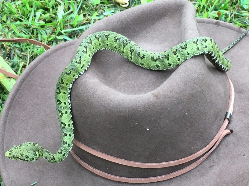
Central American Eyelash-Viper Bothriechis nigroadspersus -

Red-eyed Tree Frog Agalychnis callidryas -
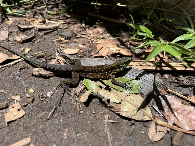
Middle American Ameiva Holcosus festivus -
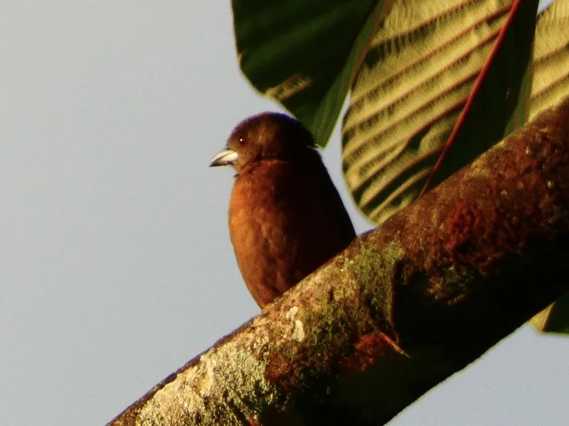
Scarlet-rumped Tanager Ramphocelus passerinii -
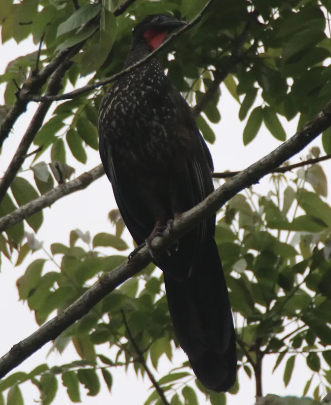
Crested Guan Penelope purpurascens -
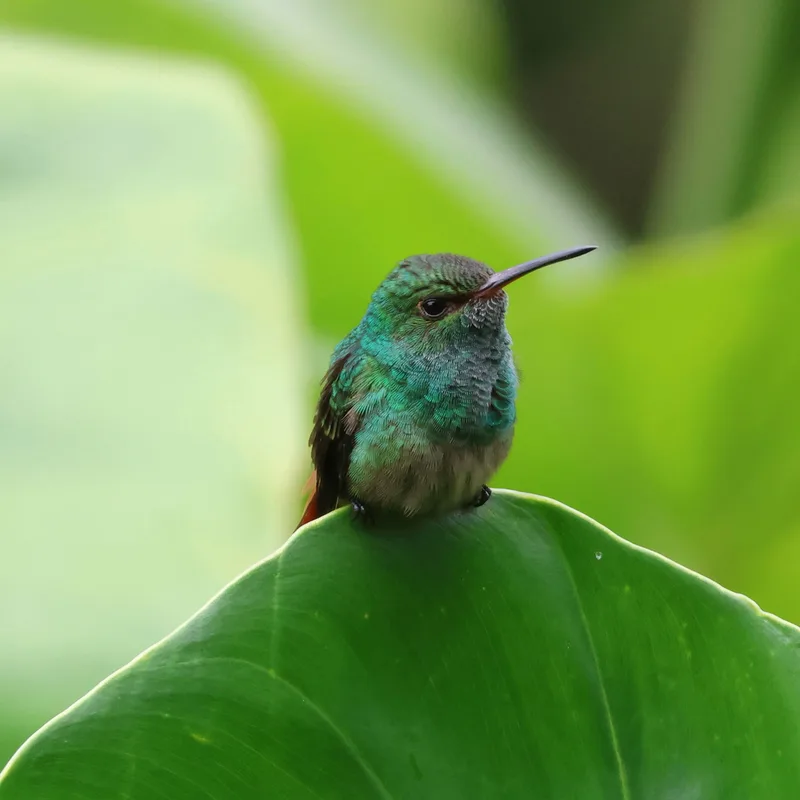
Rufous-tailed Hummingbird Amazilia tzacatl -
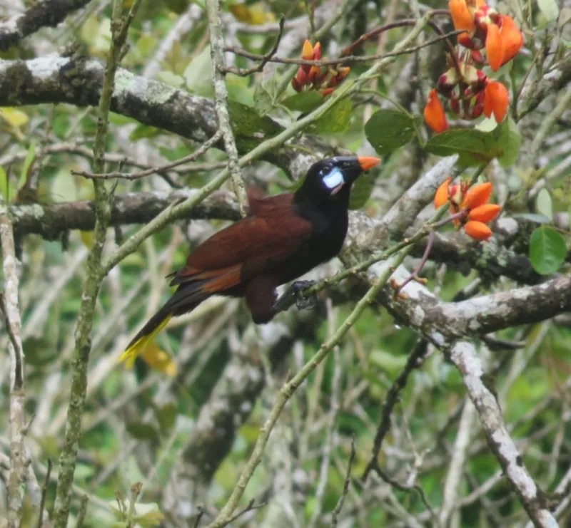
Montezuma Oropendola Psarocolius montezuma -
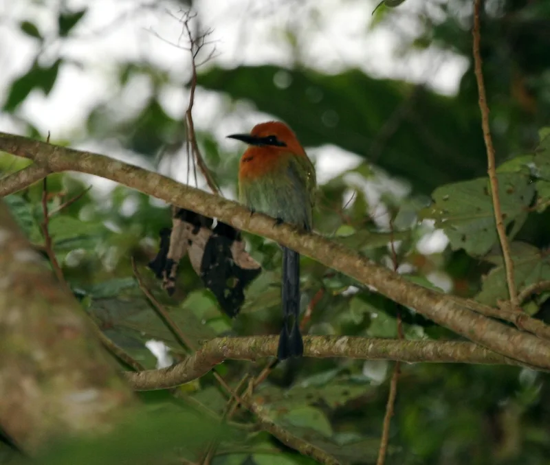
Broad-billed Motmot Electron platyrhynchum -
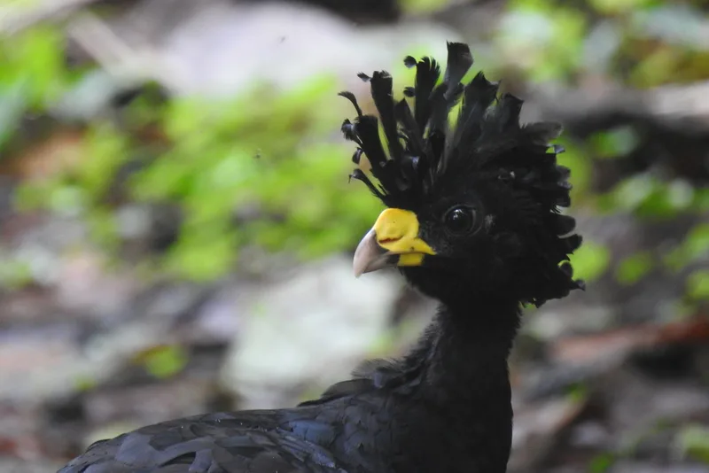
Great Curassow Crax rubra -
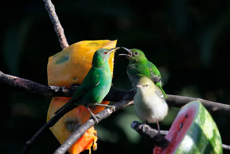
Green Honeycreeper Chlorophanes spiza -
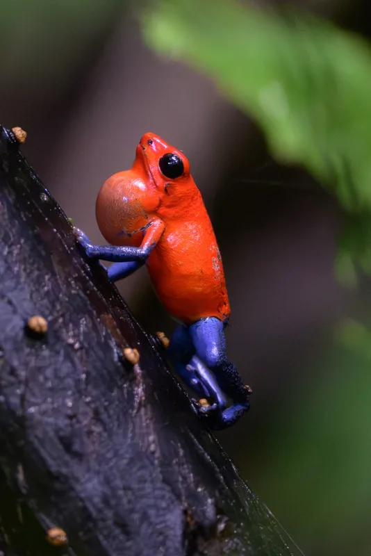
Strawberry Poison Dart Frog Oophaga pumilio
Field Notes · Volcanic lens · Arenal Volcano · 10.4288, −84.7032